Les’s Winter Weather Outlook 2009-2010
It’s that time of year again! It is fall and winter is right around the corner. The following post is going to contain my thoughts as to what I expect across the region for the November – March period 2009-2010. I will be discussing many things such as our current pattern and the factors leading up to our winter time pattern. I will be showing graphics depicting factors such as El Nino, temp and precip trends, snow cover, the on going solar minimum and much, much more!
Fall 2009 – The Current Pattern and Trends
I always begin every Winter Outlook looking at our current weather pattern as that can sometimes give us clues as to what the upcoming winter will bring. We have basically been stuck in a relatively cool and stormy pattern over the Midwest since last winter. The maps below will clearly show the temp. and precip. departures over the country for the past 30 days.
Temps:
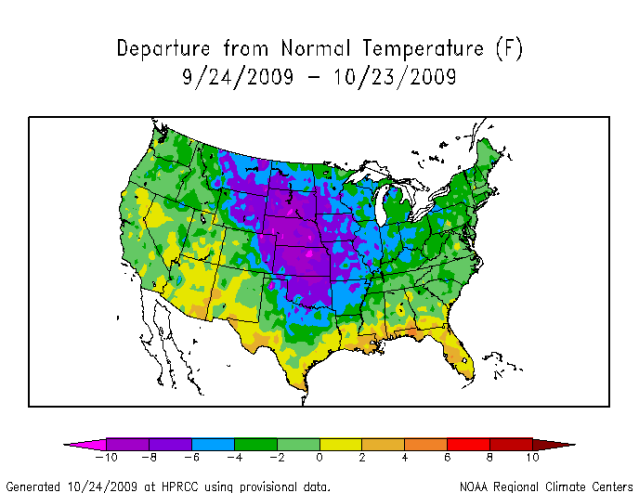
Temps:
Precip:
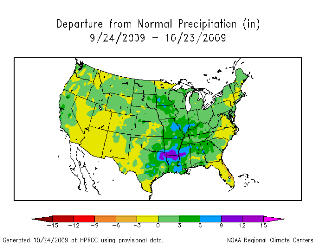
You can clearly see that the mean trough has been positioned over the Plains. The temp. trends reflect this quite nicely. The precip. trends also tell us where the storm track has been. Drier conditions have existed over the SW CONUS as well as along the East Coast. We have been seeing a ridge over the SW, a trough over the Plains and Midwest and another ridge over the East Coast.
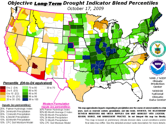
Soil moisture is also a very important clue. Again, look at the soil moisture map below and you can see the areas that have been very wet.
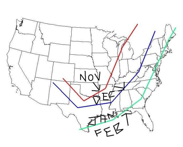
For the upcoming winter, I expect the mean trough position to continue to be right where we have seen it for Nov, and then late in the month or in early Dec., I expect the mean trough and storm track to shift east, putting the Ohio Valley in a favorable area for snowfall. As we roll on thru winter by mid to late Jan and Feb, the storm track should shift to the Eastern Apps / East Coast regions. See map below.
El Nino
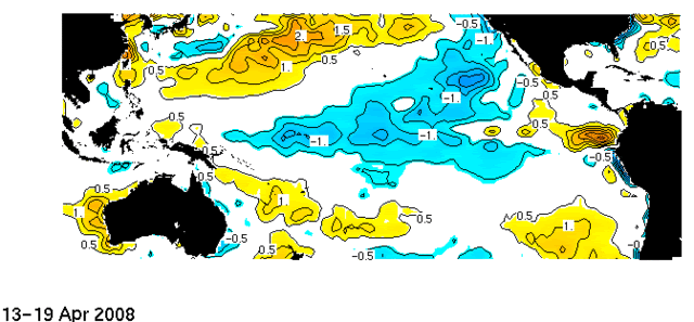
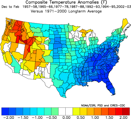
El Nino has been the talk of town this year. The El Nino has been weak for the most part but the Pacific waters have warmed considerably over the past month due to a Westerly Wind Burst (WWB) and enhanced MJO activity. I expect one more of these WWB’s to come in during the month of November. Weak El Nino conditions favor cold weather over the Eastern US for winter versus moderate or strong events. The map below is a composite of temp departures of all Weak El Nino winters since 1950.
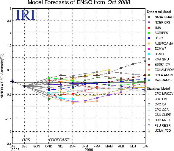
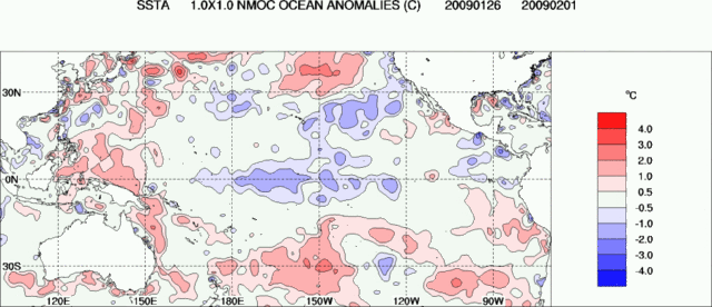
However, due to the recent warming, I expect El Nino to reach moderate status before weakening by about December. Below is a loop of the sea surface temps. departures from Feb 2009 thru October 2009. As you can see, we began with a La Nina and we have transitioned into an El Nino now.
The ENSO models for October fit my thoughts very well with a moderate peak in December and then it weakens for the second half of the winter. When we peak and fall in regards to this El Nino will have an impact on how much cold and snow we get here.
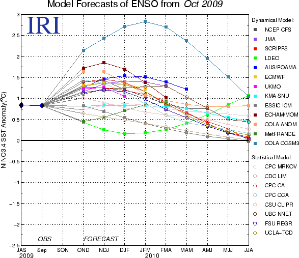
Currently, I do not expect a dry and mild winter. Those are the typical impacts from a Strong El Nino and we clearly are not going to see this occur. We should see just the opposite. I have more evidence supporting a colder outlook and a stormier one as well.
QBO
A negative QBO does support more high latitude blocking in the Northern Hemisphere. The QBO has been in the negative teens for the past few months and I expect that to remain that way for the winter. This could help assist us in getting a West Coast / NW Canada Ridge going which in return allows a Trough to develop over the East.
NAO
The NAO when in a negative phase also promotes stormy conditions and colder conditions for us as well. I expect the NAO to be ever changing. The NAO has been negative for a good chunk of October and we have been very cold and stormy so far. We have seen a few milder says as of late because the NAO has risen. As the state of the NAO changes phases, big storms can often develop. I expect a very stormy winter and this is one of the reasons why. If the NAO stays around neutral or slightly negative, then the storm track should favor us /vs./ having a Lakes Cutter system or an East Coast system.
PNA
The PNA when positive supports a ridge out West and a trough over the East. Like the NAO, I expect this phase to change throughout the winter season. Due to a moderate El Nino, a strong Pacific Jet I do not believe will allow the Western Ridge to stay intact for very long. We will see cold air outbreaks at times, especially during the second half of the winter as El Nino weakens, the NAO tanks, and the PNA should go mainly positive. This should allow for a pretty cold pattern for Jan and Feb. For the first half of winter though, the Pacific Jet should stay strong and a –PNA pattern should be the end result. This does not mean that we’ll blow torch at all, but it does ensure an extremely stormy pattern will occur for the region. If the storm track is correct, then we get nailed with heavy wintry precip.
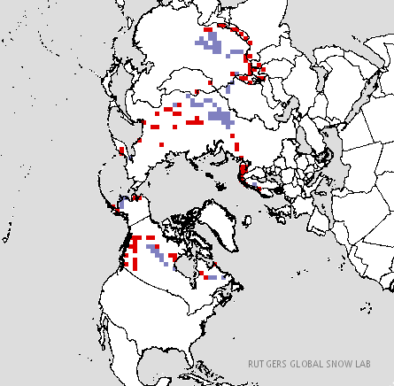
Snow Cover
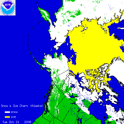
The current snow cover has been expanding rapidly over Arctic Canada and the sea ice has been building pretty good as well. The graphic below shows this.
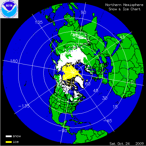
Now, how are we doing relative to avg for this time of year?
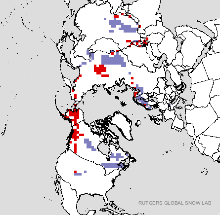
As you can see, we’re not doing too bad at all. This is about right where we should be minus Western Canada. But, warm and dry conditions have occurred there so this is why that area has been below avg in snow cover. Current computer models though do suggest that the cold and snow will continue to build even in Western Canada in the upcoming weeks. We should have a nice supply of cold air for storm systems to tap into.
PDO
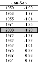
We are in a cold phase of the PDO. A +PDO combined with a Weak El Nino usually produces some of the coldest winters on record for the Eastern US. The PDO has been rising towards neutral over the past 2 months and the index value was actually weakly positive for Sept. For the upcoming winter though, I do expect it to cool once again and remain near Neutral or weakly negative. If we do see a –PDO and a –NAO though, check out the results.
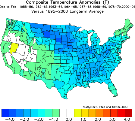
The nation as a whole is pretty cool.
Solar Minimum
We are in the midst of a multiyear solar minimum. We have not seen the sun this quiet in our lifetimes. This is a big factor why I do not expect the strength of the Pacific Jet and El Nino to blow torch our temps. this winter. The sun has produced no sunspots 79% of the time so far in 2009 (per spaceweather.com). The oceans are cooling and so is the globe. Record snows have been occurring in other parts of the World already this year and I expect portions of Canada and the US also to be setting records for cold and snow. Someone is going to get pounded this winter but as always, the question is who?
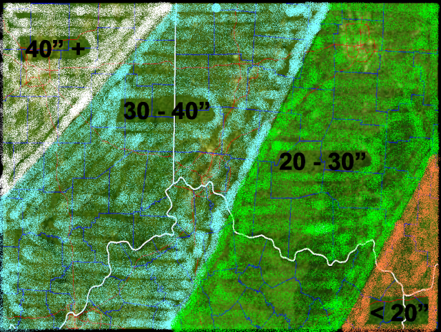
Where Does the Ohio Valley Stack Up?
As you can see, I have presented a lot of data that points to a cold and snowy winter for us. But, I have also presented a few things that do not. The good far outweighs the bad though. Below, I will present a monthly break down as to how I see things going for us.
Nov – I see a continuation of the current pattern for at least the first half of the month. The mean trough position remains to our NW. We’ll see a lot of Lakes Cutter storms. The snow cover should build though quite nicely to our NW in places such as the Rockies, the Dakotas, Nebraska, Kansas, and the Upper Midwest. This is good news as storm systems will be able to tap into the cold air more easily down the road. By mid to late month, I expect the mean trough to begin to shift East. I expect our first accumulating snow to occur in late Nov.
Dec – As the storm track begins to shift to the East, I expect Dec to be a good month for snow. Due to the factors I have mentioned above, the strong Pacific Jet will keep the storminess going. I expect the SE Ridge to come into play, however, it should be positioned further to the East and be much flatter to produce more inland runner systems. I expect to see a couple of storms track to our SE up the Apps. to give us a pretty snowy month relative to average. Due to the strong Pacific Jet though, we can see a couple of milder periods also as the pattern reloads.
Jan and Feb – I expect Jan to start off the same as Dec. By mid to late month though I expect conditions to turn very cold. The storm track should be along the Eastern side of the Apps. transitioning to East Coast Lows by late Jan and Feb. For us, cold air will be the bigger story, but we should see numerous Clipper systems reinforcing the cold air over our region. The tracks of these clipper systems should be favorable for the Ohio Valley, especially the Southern OH Valley to get in on the action. I expect El Nino to be weakening and the NAO moving into more of a negative state. As El Nino continues to weaken and the NAO continues to tank in Feb., the mean storm track should be East of us, and we may miss out on some of the bigger snow events, however, Clipper systems will keep our snow appetite satisfied and the cold air should keep it on the ground for a while also. Temps should avg well below avg for these 2 months and a few mornings below zero are not entirely out of the question.
Mar – I think one decent snow event is possible during the first week or so of the month before we begin to see some miler days during the second half of the month. This month is so far out in time, that I really don’t have a lot of thoughts at this point as to how winter will finish.
In conclusion, winter temps. as a whole should end up below avg for the period as a whole. Snowfall should be above avg. Due to the mean trough being out to our West as winter begins, and slowly getting more favorable for us by Dec and early Jan, I expect the highest snowfall totals to be to the NW of the Tri-State. For CVG, we should do very well also. Below, you will see my snowfall map for the Ohio Valley.
If you have any questions, just ask. Please feel free to agree or disagree as well. Thanks for reading!