10/20/07 11pm
Welcome to my Winter Weather Forecast for the OH Valley for the 2007/2008 season! Sit back and relax and I hope you find this to be an enjoyable read.
FALL 2007
Fall started out where summer left off. A
persistent ridge of high pressure over the Eastern US kept us high and dry. We were much above normal in temps. and much below normal in
precip. The pattern remained the same for the first week of Oct. as well. Temps. are still running above normal as I write this forecast, however, we have finally begun to see an increase in
precip. We just went through a stormy 2 day period this week, and the potential exists for another 2-4 day
precip. event for next week.
As we end Oct. and begin Nov., I expect us to be colder then normal for temps. I think we could see our first freeze in the first week or two of the month. We may begin to see milder temps. towards the later part of the month, but overall, I expect temps. to be below avg. for the month and above avg.
precip. I see the drought continuing to improve for our region as well.
LA NINA:
Now on to some things that I am taking into consideration when making this forecast. First of all, as most people know, La Nina is the cooling of the Pacific waters down by the equator off of South America. Typical La Nina effects on the OH Valley are warmer then normal temps. and above normal in
precip. However, temps. are highly dependant on the strength of the event. Weak to Moderate La Nina's can give us cooler to slightly above normal in temps. while strong La Nina's can give us much above normal in temps. Currently, La Nina has been
strengthening into a moderate event. Some of the long range models expect it to become a strong event, while others keep it moderate and even weaken it some by
December or Jan.
Here is a current snapshot of La Nina.

Note that small area of warmer water just to the North of the cooler water just of the South American Coast. Could La Nina have reached its peak, or is this just a temporary
fluctuation?
Here are the Four
Nino Regions Below:
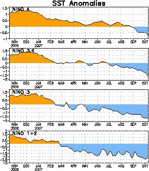 Nino
Nino Region 3.4 is the one that is officially used when a La Nina (or El N
ino) is declared. Note, how it continues to drop, meaning that La Nina is getting stronger. However, look at the other regions. Regions 3 and 1+2 are both starting to warm a little bit. Again, is this temporary, or will they drop again? Only time well tell.
THE
NAOThe
NAO stands for the North Atlantic Oscillation. Typically, when it is in a negative phase, the Eastern US will see colder and stormier weather. In a positive phase, the Eastern US typically sees warmer and less stormier weather.
Here is the most current
NAO forecast for the next 10 days:
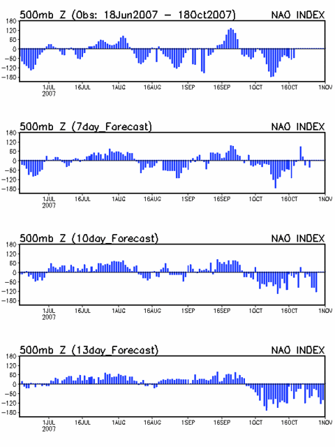
As you can see it is forecast to be negative by months end, and this is one factor that I used in my Nov. cold start to the month forecast from above. The
NAO really can not be accurately forecast more then one or two weeks in advance. But, for what its worth, I think for Dec., the
NAO could be negative for the month.
I'd like to show you a model image from the German Climate Model for the month of Dec.
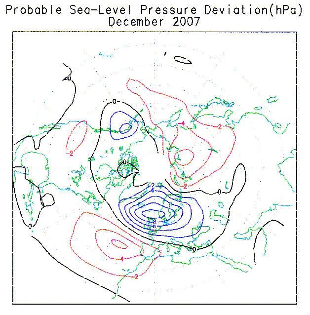
Now, this is
technically not a negative
NAO, but rather a
Scandinavian Block. If this block though forms a little further West towards Greenland then Dec. could be a cold and possibly snowy month. It'll be interesting to see what happens.
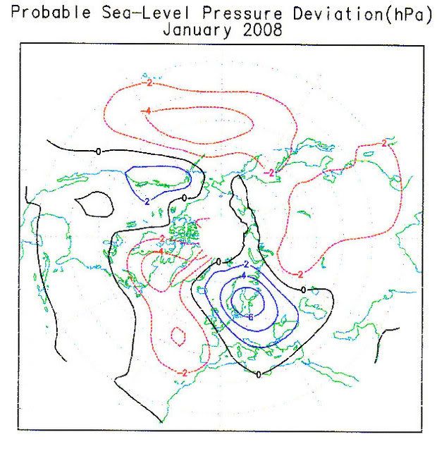
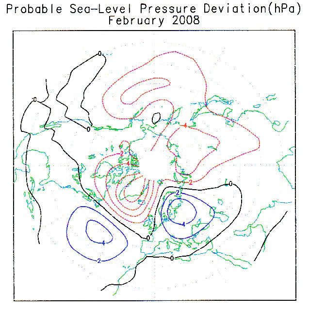
For Jan. and Feb., the
NAO is shown to be slightly
positive in Jan. and majorly positive in Feb. Below, are the German Climate Models for Jan. and Feb. below.
Jan 2008
Feb 2008
THE
PNAThe Pacific North American index can be summed up easily. If it is negative, that typically
depicts a trough in the West and a ridge in the East. The opposite is
true for a positive index.
Here is the 10 day forecast of the
PNA below:
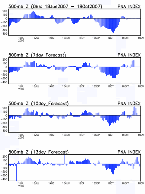
This is another reason why I am going with a cold start to Nov. since it is forecast to be positive.
THE
QBOThe
QBO is another index that measures the Easterly and Westerly trade winds blowing over the Pacific in the upper levels of the atmosphere. The
QBO has been extremely negative and has continued to drop even at the end of Sept. This means that it is in a strong Easterly Phase. Not too much is known about the
QBO, but to favor a cold and snowy winter in the Eastern US, we do not want to see the value this negative.
See the graph below.
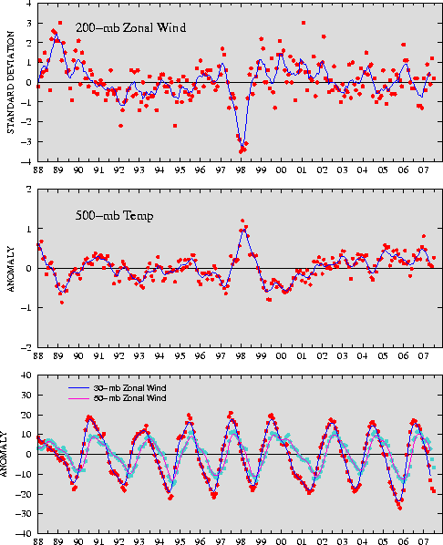
I do expect the
QBO to weaken during the winter and for it to start making a rise back towards positive. Unfortunately, I do not have October's index yet as it won't come out until the first week of November. But it'll be interesting to see if it starts trending the other way or not.
ARCTIC
SNOW COVER:
As we all snow Arctic
snow cover plays a huge role in getting arctic
air masses to build up and modifying less as they head down into the Lower 48. The
snow cover and sea ice is way below
normal this year. However, it has begun to build. A lot of forecasters think that we won't see many arctic outbreaks due to this. However, I disagree. It is still early and things can change quickly. I have already seen
snow cover beginning to build in Alaska and Canada with explosive development going on in Siberia. With a negative
NAO we could see good cross polar flow to send some of that cold air over the poles and down into the Lower 48. We have 40 days or so yet before Dec 1st gets here and a lot of things can change.
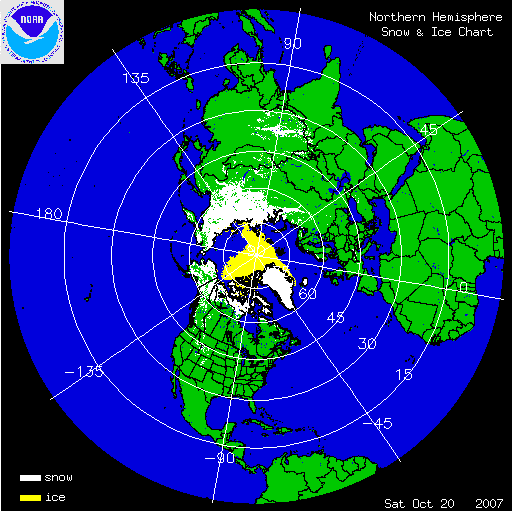
Below, you will see the current
snow cover map:
WINTER WEATHER OUTLOOK FOR THE OHIO VALLEY
Now, for sensible weather... I expect this winter to be a
variable one in terms of both temps. and
precip. types that we can expect. This is typical for La Nina winters. At times, when the SE Ridge is strong, then we'll see rain versus snow as the storm track will b
e to our North and West. At other times,
when the ridge is gone (like when the
NAO is negative) then we'll see the track to our South, which will allow us to be on the colder side of a storm system, and we'll get snow. I think this year, the OH Valley will be on the battle line between the SE ridge and the colder air to the North and West. I expect lots of storminess this winter and large temperature swings. Overall, I expect our temps. to be above normal, and
precip. to also be above normal.
Mean storm tracks throughout the winter:

SNOWFALL OUTLOOK:
In terms of snowfall, I expect the further North and West you go, is going to be your best chance at getting above normal snowfall. I think for us here in the Cincinnati
Tri-state, I think near to slightly above normal snowfall can be expected with amounts of between 20-26" for the season. Normal snowfall for
CVG is 22".
My Snowfall Forecast for the Wilmington Forecast Area:
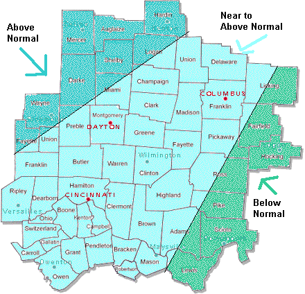
In conclusion, I expect 60 one day and 20 the next. Some storms will be bring rain and others snow. Due to us being on the battle line, as depicted in my above map, I expect an increased threat for an ice storm or two as well. We'll see a lot of rain changing to snow events also. The potential is there for a blockbuster storm or two (over 8") as well due to this pattern configuration. Hang on folks, as I think it'll be a bumpy ride this winter. You may have read a lot of things by other forecasters that winter is over! I totally disagree and hope that my Outlook sheds some light on it.
Thanks for reading and let the fun begin!