Wednesday, August 29, 2007

Another Heat Record Broken - Could the Pattern be Changing Soon?

08/29/07 8pm

In this addition of my video forecast, we broke another historical heat record today for the most 90 degree days in any month at CVG! Also, scattered storms occurred in the region along with some severe wx in Michigan. Could our pattern be changing by mid month??? Click on the link to watch the video.

http://video.google.com/videoplay?docid=-7096350578249971927&hl=en


Also, here is my updated 7 Day Forecast.


Sunday, August 26, 2007

The Heat Continues - The Drought Intensifies

08/26/07 9pm

In this addition of my video forecast, I will discuss the heat for this week. Also, Columbus, OH, experienced some severe weather yesterday. Our drought is intensifying as well. Click on the link below to watch the video. Enjoy!

http://video.google.com/videoplay?docid=8802329732260136247&hl=en

Here is my updated 7 Day forecast:


NOTE: The USA Weather Network forum now has a new home. You will need to sign up again.

http://usaweather.ipbfree.com/

Wednesday, August 22, 2007

More Record Heat

Here is my updated Video Forecast and 7 Day. This video, in my opinion, is my best yet. I hope everyone enjoys it!

In this edition, I talk about our record heat, a weak cold front for Sunday, flooding in Northern Ohio, and the quiet tropics.

http://video.google.com/videoplay?docid=7182992579677668252


Sunday, August 19, 2007

Erin's Leftovers to Impact the Region

8/19/07 9pm

Due to the positive feedback that I have received from my first ever Video Forecast, I have decided to do them full time now. Therefore, I have done another tonight. This forecast discusses Hurricane Dean, and also the leftovers of Erin, since it should be impacting our region during the next 48 hours.

http://video.google.com/videoplay?docid=2032814696814165470&hl=en

Also, here is my updated 7 Day as well:

Wednesday, August 15, 2007

First Ever Video Forecast!!!

8/15/07 11:30pm

This blog entry will be VERY short. I am trying something new, and I would like everyone's feedback on this.

I have a new addition to my forecast now. I have created a VIDEO FORECAST! Check it out, and go easy on the comments, since this is my first time.

http://video.google.com/videoplay?docid=-2985261964645604210&hl=en

I would also like to give a special shout out at this time to Trevor! Without his assistance today, I would have never, and I mean never... would have been able to create this video! Thank you very much for your help!

Also, my updated 7 Day as well...

Sunday, August 12, 2007

Dry Weather Continues - Could Dean Develop in the Tropics?

8/12/07 5pm

After a dry weekend, the dryness continues into next week. High pressure will remain in control. Temps. and humidity will not be as high this week, as we have experienced in the past 2 weeks. The Burlington Weather Office did record another 100 degree temp. today! This makes the 4th one this year of 2007. I topped out at 101.0 as of this blog entry. That should be the high for today.

On this afternoon's weather map, a cold front extends from Michigan SW to just North of Chicago, Iowa, and Nebraska. Thunderstorms pushed thru Michigan this morning. High winds, small hail, lightning, and very heavy rain occurred. Winds this morning gusted to 50 mph. Over us, high pressure continued to rule. The heat ridge has retrograded off to the West and will remain over the Central Plains this week. Check out my Surface Map below.


The 90s will continue this week, but the humidity will be lower then in the past week. Our next front looks to affect the region on Thursday, late in the day. The models are keeping most of the energy to our north, as has been the case for most of this year. The front looked stronger also a few days ago. But, the models are trending weaker with this system, so I have only included a 30% POP for Thurs. afternoon in my 7 Day. Below, is the 12Z GFS's take on the front valid at 102 Hours.


High pressure and somewhat cooler temps. will move in behind the front. The Euro brings us much cooler air for the end of the week, but the GFS has strayed away from that idea. I did take temps. below 90 for Sat. as the GFS MOS Guidance shows mid 80s, and I think with the front being weaker on Thurs. then earlier predicted, that cool push of air behind the front, should not be as cold as what the models are predicting.

The 12Z GFS brings in another weak front for Sat., but I am keeping the forecast dry at this time, due to model uncertainty and also due to the fact that it's so far out in time. Here is the model image valid at 138 Hours.


Here is my updated 7 Day Forecast:


Long Term Outlook (Aug 20th - 28th)

The long range period begins with another Great Lakes MCS Aug 20-21st. A trailing cold front looks to deliver us another shot at rainfall. Meanwhile, the models still show a tropical system affecting Southern TX or Mexico Aug 23-25th. I'll touch on this in greater detail below. For us, more high pressure and dry weather remains for the rest of the forecast period. The Drought Monitor Map, which will come out on Thurs., should paint a pretty grim picture for the region.

Could Dean form in the Tropics?

The models have been consistently showing that a tropical wave off of Africa will develop in a few days possibly becoming a Depression and then Dean! Here is an IR Sat. image of the Atlantic Basin and you can clearly see a tropical wave off the African Coast.


As you can see, the system has great circulation with it, and it should be heading into an environment which will be more favorable for development. However, note the lack of convection with this wave. I think that it will develop into a depression in the next 2 or 3 days, and then eventually become Dean.

The models are showing the system eventually tracking thru the Caribbean Sea and into the Gulf of Mexico by Aug 23-24th. It may even strike Southern TX or Mexico! Here is the 12Z GFS's depiction of it valid at 252 Hours.


The GFS has been all over the place with the track of this system. 4 or 5 days ago, it had the system tracking towards the East Coast, then deflecting it back out to sea. Then it had it hitting Florida. Now, the model takes it thru the Gulf and into S. Texas or Mexico as you can see from the above image. I'll continue to monitor this tropical wave, and it if becomes Dean or not.

Wednesday, August 8, 2007

Isolated Storms this Evening and Tomorrow - The Heat Continues...

8/8/07 8:30pm

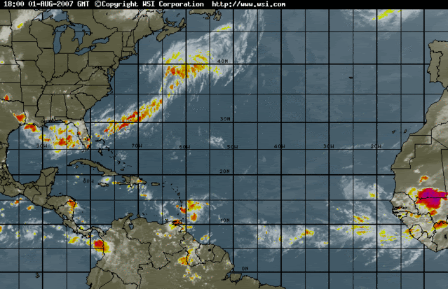
As of this blog entry, the Burlington Weather Office is reporting a T-storm with a temp. of 84.6 degrees. Precip total: 0.04". CVG today picked up 0.11" Below, you will see a GR Level 3 Radar image as of 8:20pm, when the first drops began to fall at the Weather Office.


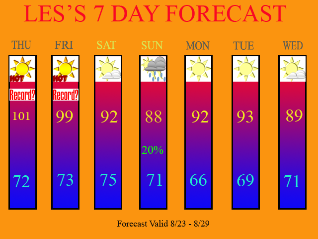
As predicted, we have definitely have seen some dangerous heat across the region this week. That will continue for one more day. The 12Z GFS MOS Guidance has 101 for tomorrow. I am forecasting 100! Today, CVG hit 100 officially for the first time in 8 years! The last time we hit 100 was July 31st, 1999. We also broke a record high, which was at 99, set back in 1999. Below, is the public information statement, which was released by the NWS in Wilmington, OH.

... Record high of 100 degrees set at Cincinnati...

The temperature at the Cincinnati-Northern Kentucky International
Airport reached 100 degrees at 258 PM today. This broke the record
high for the date which was 99 set in 1999. This also Marks the first
time since 1999 that the Cincinnati Airport reached 100 degrees. It
is possible that the temperature will rise even higher later this
afternoon.

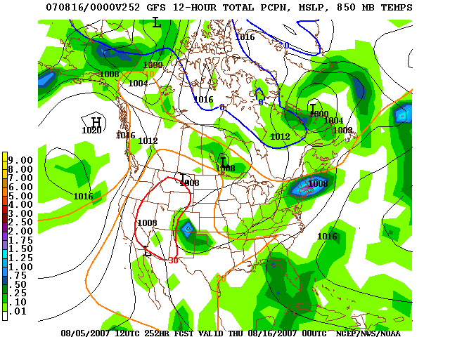
At the Burlington Weather Office, I recorded 102.4 yesterday and 104.8 today! I also expect tomorrow to be day 3 in a row for Burlington with 100+ degree temps! Tomorrow will be our last day for triple digit heat. The ridge of high pressure, which has been dominating our weather, will retrograde off to our West. In doing so, a stationary front, which has been producing heavy, flooding rains in Southern MI, Northern IN, and OH, will finally sag far enough Southwards by tomorrow afternoon and evening, that isolated T-storms will be possible across the region. The 12Z GFS keeps most of the moisture to our North. Thus, I have inserted 20% POPS for tomorrow. Here is the 12Z GFS model image valid at 18 hours.


Afterwards, we will briefly drop below the 95 degree mark. In fact, on Friday, we will struggle to even hit 90 degrees! The record at CVG for the most consective days of 90 degree temps. stands at 16 days. We are currently on Day 10 counting today. If Friday turns out to be a 90 degree day, then our record could be threatened! WOW... amazing stuff! Record heat and drought-like conditions! Being that you guys are blog readers, you heard it here! Way back in the Spring, I predicted a hot and dry summer. Besides July being cooler then avg (but below normal in rainfall), my summer seasonal forecast has been right on the money!

The weekend will continue to offer dry conditions, with temps. once again approaching the mid 90s by Sunday. The ridge of high pressure will re-build over the region for early next week. This will continue the hot temps. and dry conditions across the region.

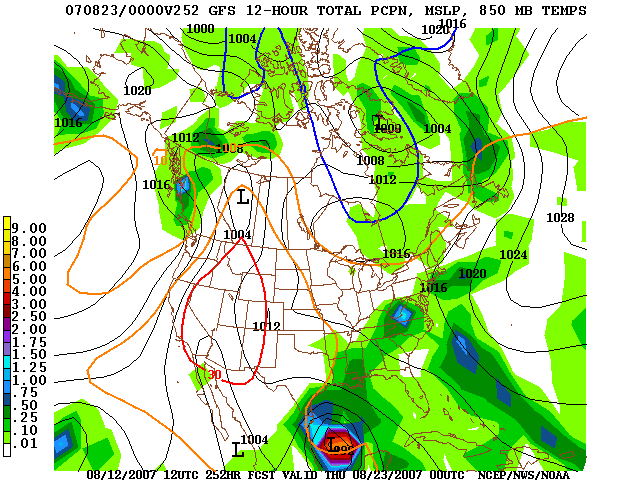
Now, the 12Z GFS does try and bring a front thru on Monday, but notice in the below image, again, all of the moisture is to our North. Thus, I am leaving Monday dry at this time.


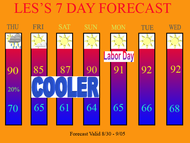
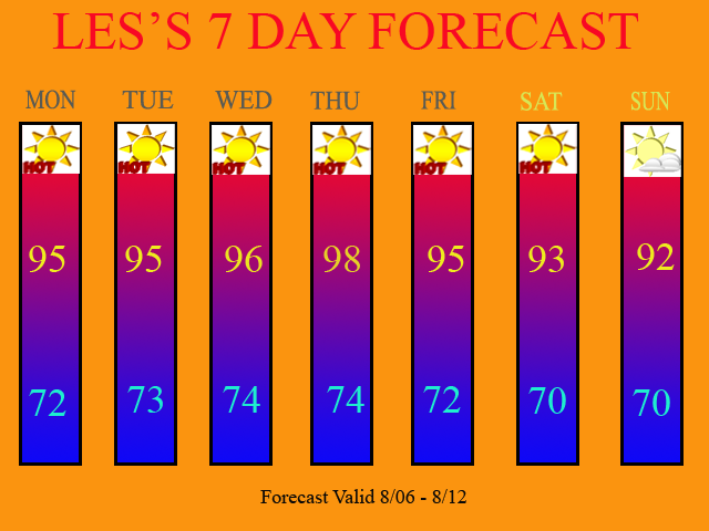
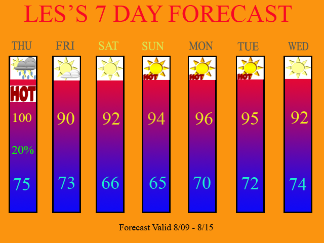
Below, you will see my updated 7 Day Forecast.


Long Range Outlook (Aug. 16th thru Aug. 24th)

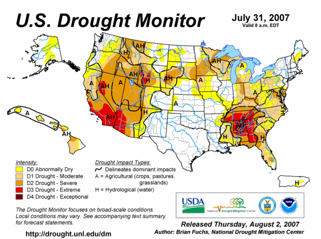
The 12Z models call for more of the same. The ridge will continue to dominate and only slightly weaken from time to time, allowing for 20-30% coverage of storms, maybe once or twice a week. The 90s will most likely continue during the next 2 weeks as well. The drought will likely worsen and on tomorrow morning's Drought Monitor Map, we should see that be the case. I expect the D3 area to probably return to Southern KY, and the D2 area should expand in our area as well. The next DM Update on Aug. 16th should show my prediction quite nicely if it does not occur with this week's update. Check the USA Weather Forum after 9am tomorrow morning, and I will post the new map for Aug. 9th in our Drought of 2007 Section. The website is: http://www.createforum.com/usaweather

Sunday, August 5, 2007

Dangerous Heat Expected This Week

08/05/07 2:45pm

Well folks, we did see a little bit of rainfall today, but most areas saw very little. Here at the Weather Office in Burlington, I picked up 0.18" and CVG picked up 0.23". Temps. are now rising rapidly, as we are now up to 91.6 as of this blog entry, and CVG is now up to 88 degrees as of the 3pm reading. The dew point, (DP) or measure of the amount of moisture in the air is at the highest level for 2007! The current DP is at 77, which generally can be found along the Gulf Coast! We truly have a tropical air mass in place across the Tri-state.

So, what can we expect for our upcoming work week? More of the same. I expect this dangerous heat and high humidity type of weather pattern to continue. The 12Z GFS model run showed no relief from the heat. Below, is a surface map that I made this morning.


As you can see, there is a trough over Western Canada and the Pacific NW. This is causing the Heat Ridge to move Eastward and take up residence over the SE US. The warm front is now to our North. It currently runs across Northern Indy and Northern Ohio, and should stall this evening in that region, or perhaps over Southern MI.

As I stated in my last blog entry, the storm track should remain to our North. However, even the Great Lakes will not be seeing as many MCS's as the models once showed. This heat wave will be affecting the Central/Southern Plains, and most of the Eastern US as well. We have not seen heat this extreme and humidity values this high for a long time now. The 12Z GFS MOS Guidance showed 99 or 100 by Thursday for CVG. I am not going that high due to afternoon cumulus cloud development and high humidity values. I do not think that we will crack 100 this week. Some home thermometers may do so, but not any official reporting stations, such as CVG. If you want to find a 100 degree temp. then go to Louisville down to Evansville, IN. That area should crack 100 by Wed and Thurs of this week.

Here is my updated 7 Day. I left all POPS out of the forecast. The 12Z runs have taken away all precip. chances. Now, from time to time, we may get a pop-up afternoon storm, but the coverage will be so isolated (less then 10%) that I have dropped all POPS from the forecast.


Long Term Outlook: Aug 13th - 22nd)

The 12Z GFS continues this pattern with no relief in site. The only significant chance at rain that I could find is on Thurs., Aug 15th. This particular front still looks to have most of its moisture to our North. Here is the 12Z GFS model image valid at 252 Hours.


I look for the drought to worsen as most of the Tri-state, South of the I-275 Loop in Ohio, should be in a D2 status by our next Drought Monitor Update, with D3 probably coming back to Southern KY. CVG is currently over 10" below normal in rainfall for the year. We can not turn to the tropics for help, as there is absolutely nothing going on whatsoever. Last year, the tropics were dead, and this year is turning out to actually be quieter then last year.

Thursday, August 2, 2007

Hot and Dry Pattern to Continue

8/2/07 5:30pm

Well, if you like the 90s for highs and no rainfall, then you will enjoy reading this blog entry. The forecast will be right up your alley! If you dislike this kind of weather, well, please continue to read the blog anyways.

Our current weather pattern is depicted by my Surface Map graphic, which is shown below.


As you can see, the jet stream is in its typical summertime position, which runs along the US/Canadian Boarder. You can also see how much of the country is dominated by high pressure. Now, what I want you to pay particular attention to, is the top part of the ridge, which I have labeled as "flat." What that means is that there is a portion of the ridge where our storm systems will continue to track along, a weakness in the ridge if you will. Storm systems will continue to track well to our North over the Great Lakes region. Basically, this leaves us underneath the ridge and stuck in this hot and dry pattern.

The 0Z GFS model from last night was showing some decent rainfall for us this Sunday, as the cold front was supposed to break down the ridge and push all the way down to the OH River. The 0Z NAM showed the opposite. It kept the cold front at bay to our North. I figured the GFS run to be a bogus run. I was right. Check out the 12Z GFS run from this afternoon for Sunday. You'll notice how it too agrees with the NAM model and keeps the front and its associated precip. to our North.


Therefore, I expect Sunday to be dry for us with the storm track up to our North. As we continue thru next week, I expect more of the same. By Wed. and Thurs. I did insert a small 20% POP into the forecast as the models are showing a slight, and I mean a slight chance of a few afternoon pop-up storms as another front tries to make it down here. As you can see by the 12Z GFS model image, which I have posted below, the main storm track continues to be over the Great Lakes, as storm systems continue to track along the top, or flat part of the ridge. Below, you will see the 12Z GFS model run for Thursday.


My updated 7 Day Forecast can be seen below.


Long Term Outlook (Aug. 10th - Aug. 18th)

The long term outlook features this same weather pattern. I see no change in site at this time. Storm systems will continue to ride off to our North only delivering us a glancing blow, and small chances at t-storms. I see no improvement for the drought whatsoever.

Drought Update:

Speaking of the drought, here is the updated Drought Monitor Map as of 7/31/07.


As you can see, we have seen significant improvement. The D3 area is gone as far as KY is concerned, and a lot of the D2 areas, have been downgraded to D1. You can see though an area of D2 status, which runs along the OH River. Further North, the drought continues to intensify and expand. My drought outlook calls for the D2 area to continue to expand over our region, with a return to D3 status in Southern KY once again. I am forecasting this to occur within the next couple of weeks.

The only thing that can save us now are the tropics. I do not see that happening at this time. The tropics remain very quiet as conditions are not favorable for these tropical waves to develop. Check out this IR Satellite image of the Atlantic Basin.


Also, we would need a stalled out front to sit right on top of us for a while to deliver us some soaking rains. The models are just not showing that occurring at this time. The only chances the models are showing are isolated afternoon storms, which will only benefit localized areas that receive them. Basically, keep your A/C in working order and try and stay cool over the next several weeks.