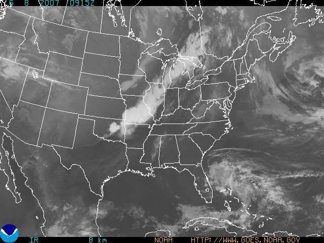
Sunday, June 24, 2007

Pattern Change - Daily Chances at Rainfall This Week

06/24/07 9pm

Well folks, the drought is not going away, however, I do think that it will not get any worse for the next couple of weeks. When we had a few MCS's affect the region starting back on Fri. of last week, they changed our whole weather pattern now. Instead of seeing a mini heat wave develop, like I was forecasting last week, this week, we will have more humidity in the air, more instability, and almost a daily threat for showers and storms. I only see 2 days over 90 degrees this week, and that will be Tues and Wed before our next cold front moves in.

Before we get to the models, I thought that the weather office might receive a T-storm this evening, but it was a bust. Here is a radar image that I saved from GR3 as of 8pm.


The cell tracked from between Union and Walton in Boone Co, and moved into Independence in Kenton Co. It then rolled into Campbell Co. as well where they desperately need the rain. The cell dropped between 0.15" and 0.45" based on radar estimates. Otherwise, most areas didn't get much but a few sprinkles or very light showers today,

For tomorrow, I think a slight chance of storms is possible in the afternoon. The 12Z GFS shows the moisture mainly North of the OH River, so I went with a low POP on
the 7 day, but the best chance of getting rainfall for Mon. will be North of the OH River. The same thing for Tues. but the chances are so low that most everyone will remain dry. Thus, my reasoning for raising the temps. into the 90s. Wed. is going to be another hot one as well, although an isolated storm could still occur. The threat is less then 10% though.

By Thurs. a cold front should be beginning to move into the OH Valley from the North. Fri. looks to be our best chance of rain though as the cold front is supposed to stall out near the OH River, or just South of it. Here is the 12Z GFS valid at 126 hours for Fri. 2pm.


The 6Z GFS from today actually had the front moving south of the region and providing us with a nice weekend. However, the 12Z GFS from this afternoon actually slows the front down until Sat. morning. So, the model trends have been to slow down the front. Thus, I have POPS in for Sat. as well. Sun. it this point looks cooler and less humid behind the front.

Here is the new 7 Day valid for June 25th thru July 1st.


Long Term Outlook (July 2nd thru 10):

At the beginning of the long term period, high pressure briefly builds in. However, by July 3rd and 4th another front looks to move in. However, at the present time, it looks weak and the moisture looks scattered with it. This, naturally will change, but that's what's going on at the present time. Then, yet another front for the July 7th and 8th time frame as well. Again, this far out, it could change.


July 4th Preview:

Here is the GFS image from the 12Z run for your viewing pleasure. This is valid at 252 hours for July 4th at 8pm.


Again, do not buy this model run as it'll change. Currently, I'd have to say a 20% chance of rain is in order for July 4th at the present time. No need to cancel any fireworks shows at all the way it looks right now.

SIDE NOTE: This will be the only 7 Day and Blog Update for this week, as I will be on another fishing trip to Saginaw, MI. The Blog and 7 Day updates will resume after July 1st.

Thursday, June 21, 2007

Chance of Storms Fri and Sat - Hottest Temps. of the Season Early Next Week

06/21/07 6am

I have lots to discuss in this morning's blog entry, so let's get to it! We had a nice day yesterday with much less humid conditions. For today, high pressure will remain in control keeping the dry weather going. Areas that could get a storm by this afternoon and evening will be well North of the Tri-state.

Now the fun begins for the Fri and Sat time period. The models have been performing terribly ever since the drought developed over the OH Valley. They tend to over estimate our precip. and they also have been too cool with temps. Take Tuesday's system, for example. Most areas received less then 0.25" and some received a trace to nothing at all. (Like the Burlington Weather Office, and CVG, which only picked up 0.03"). I think for Fri and Sat, it'll be a similiar situation. Some areas could get over an inch, but most I think will be under 0.25" and other areas could get nothing once again.

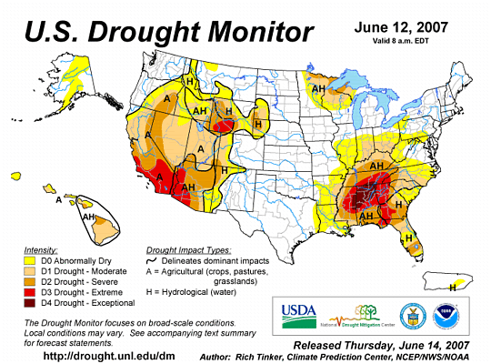
The reasoning for this poor performance is because of the drought. In many areas of the region (especially in Northern KY), we lack ground moisture. When we lack ground moisture that the T-storms use to feed off of, it is harder to get wide spread, soaking rains to develop. Also due to our low humidity values, which we have seen for the most part since the drought began, the atmosphere is able to heat up more rapidly. Also, with the dry air mass in place, the smog and haze tends to be less of a factor as well. The computer models only generate an avg. in regards to precip. coverage. It is impossible for a model to predict exactly where a T-storm may develop. It can only provide a general area where T-storm development is favorable. Keep all of this in mind as I continue to discuss the models and when you look at the 7 Day.

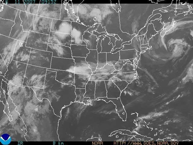
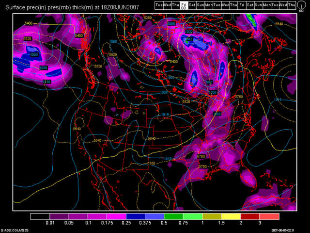
I believe that the models are busting on the position of the cold front, which is going to be dropping down from the North. This will be a key factor in the forecast and also it will dictate who gets soaked and who gets ripped off! Look at the current Sat. Pic. below:


As you can see here, the front is currently located in the Northern Plains region and the Upper Midwest. That's pretty much where it was located yesterday afternoon as well. In fact, Severe T-storms are still pounding those areas. Watches, as of this post, currently extend from the Dakotas into MN. I am leaving the 7 Day dry today because the models are forecasting the front to be in either Northern or Central Ohio by this evening. I disagree with the front being any further South then that for today.

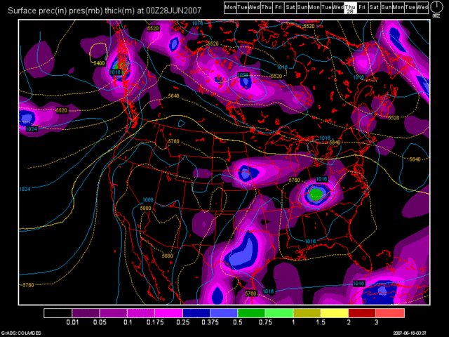
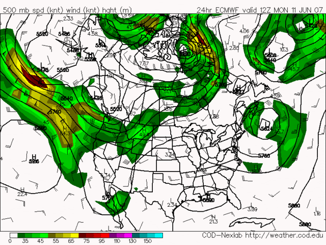
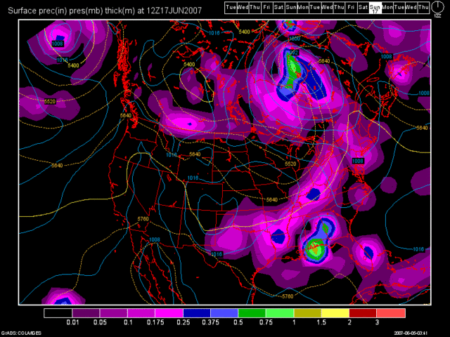
Once Friday rolls around, the 0Z NAM model has really gone crazy with T-storm (MCS) development. Look at this image valid at 48 Hours! (Sat. morning at 2am)


This model run is totally out to lunch! I mean, for starters, the NAM model is known for over developing systems anyway, and as I stated above, the trend has been for the models to do just that since we have been in this drought. So, with that in mind, I am totally disregarding this model solution and I am throwing it out the window!

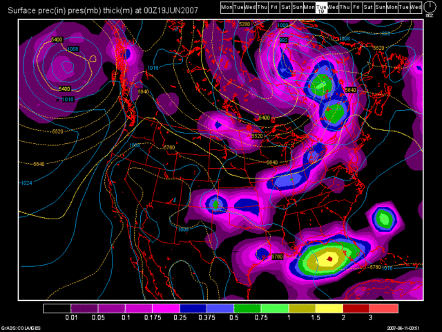
Next, let's take a look at the 0Z GFS model run valid for the same time period as the NAM.


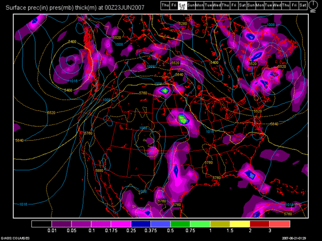
This model run is much more realistic. It shows the T-storm complex already by us, and another one developing in Southern MN/Northern Iowa. Also, the T-storm complex weakens as it heads our way. I think that the GFS though is too quick with moving the front through. In my 7 Day I have used a blend of the NAM and GFS model solutions, favoring the GFS with precip. coverage.

The SPC has backed off on any organized MCS development and severe weather potential for the Tri-state. Yesterday morning, we were in a slight risk. Yesterday evening, the slight risk shifted further North. Now look at the SPC's Day 2 Outlook, which would be for Friday. It shows the best chance of T-storms to the SW of us.


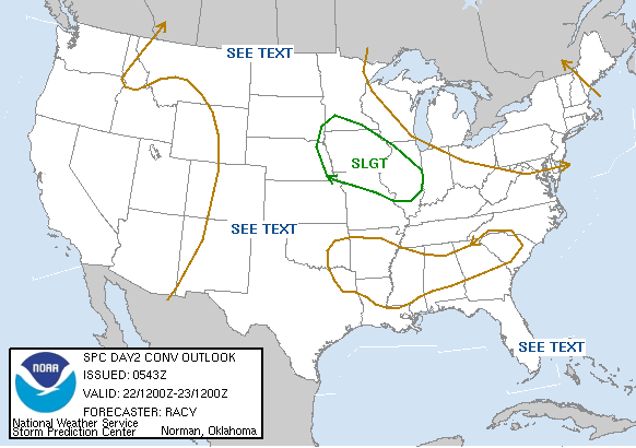
I am not going to post the Day 3 Outlook, for Sat., as it is fairly similiar as the Day 2 Outlook.

As far as temps. are concerned, if my forecast is correct, the temps. should work out just fine. If I bust, then the temps. will be much lower for the Fri. and Sat. time period. For Sun., I have left the forecast dry, because I feel that T-storm development is unlikely at this point. If anything, we may see a slight risk of a storm early Sunday morning (before 8am), but I left the 7 Day dry for Sunday at this point. Temps. will be beginning to heat up as well.

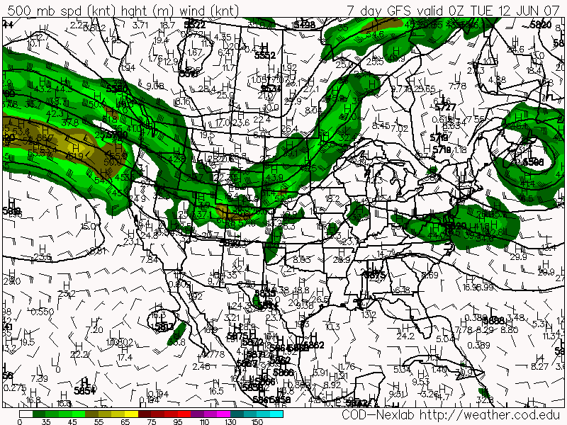
As we begin next week, the hottest air of 2007 will be moving into the Tri-State. The models are in really good agreement with the massive Ridge of High Pressure that is currently baking the Western States, expanding Eastward into our region. I went with temps. in the mid 90s for Mon. and upper 90s for Tues. My reasoning for this is because if we see little or zero rainfall on Fri and Sat, then we have no ground moisture to hold the temps. down. In other words, the humidity will be low, and the air mass will be dry. This will allow temps. to skyrocket. In fact, when I do another blog update and 7 Day update early next week, I may insert a 100 degree high temp. for Tues! If we see a decent rain on Fri. and Sat. then low 90s on Mon and mid 90s on Tues would be the case.

For Wed. of next week, the high will begin to move off to the East, and finally, there are signs that a Bermuda High type of weather pattern could be developing. I have thus, inserted a chance of storms at the end of the 7 Day, due to the fact that a moist SW flow should be developing by then. This will increase the humidity in our atmosphere as well as allowing for afternoon pop-up storms to develop in the afternoon. This is more typical of summer in Cincinnati, then what we have been seeing over the last month and a half. I probably am a shade too low on my high temp. for Wed, especially if the return flow doesn't kick in, until Thurs. Mid 90s are probably the way to go and I'll have to look at the models again when it comes time for me to do another update early next week.

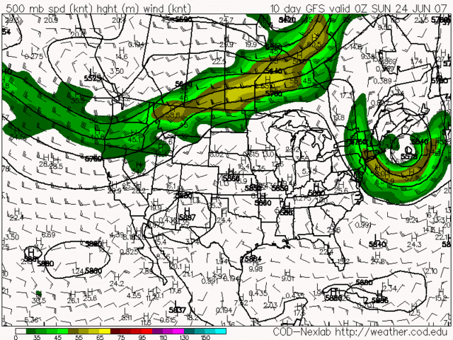
Here is the 0Z GFS model run valid at 168 hours, which is for Wed. of next week. You can clearly see the return flow that I am talking about.


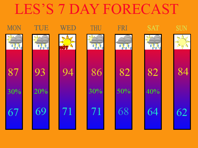
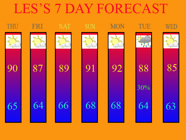
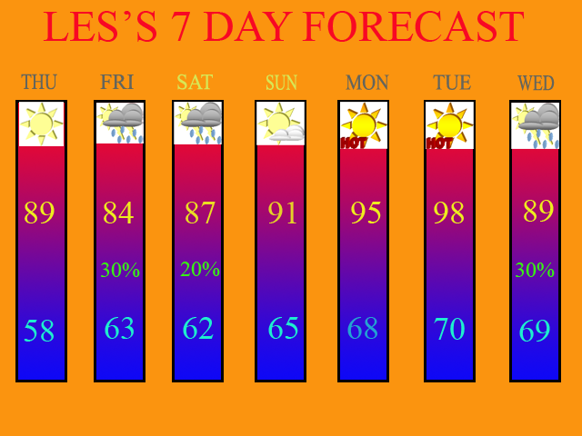
Below, is my 7 Day forecast valid for June 21st thru June 27th.


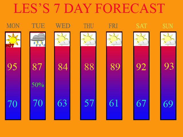
Long Term Outlook (June 28th thru July 6th)

Due to the Bermuda High type of weather pattern developing, we will be in a moist SW flow pattern, assuming the GFS is correct anyways. Therefore, as of this blog entry, a daily chance of afternoon storms would be possible thru July 1st with dry conditions thru the remainder of the long term period. High pressure looks to re-build over the region during the second half of the period.

Monday, June 18, 2007

T-Storm Threat for Tues - Dry for the Rest of the Week

06/18/07 6am

Well folks, I would like to start off by wishing all of the Dad's out there a Happy Father's Day! It was sure a hot one for Dad! CVG got up to 94 yesterday and I recorded a high of 96.2 degrees at the Weather Office in Burlington, KY. More of the same can be expected today as well before Tuesday's cold front moves through.

The models have been in decent agreement both yesterday and this morning on bringing the cold front through the region Tues. afternoon and evening. I think we stand a chance at some showers and storms Tues. morning before the front's arrival, but the best chance still will be with the cold frontal passage. Here is the 0Z GFS model run image valid at 45 hours, which is 5pm on Tues.


As you can see by the precip. legend, the dark blue area generates only around a quarter of an inch of precip. for the region. Some areas will see less, and some will see more wherever a heavier T-storm occurs. This is only an average as depicted by the model.

As far as any severe weather threat goes, slim to none at this point, especially if we get any morning convection. I have posted the SPC's severe threat probability map for tomorrow, which gives us only a 5% chance. The main threat will be damaging winds, but again, the threat is very low.


As we progress through the rest of the week, dry weather will build back in on Wed. High temps. will be nice on Wed. with a moderating trend back into the 90s by the weekend. There could be another front trying to push Southward into the region from the Great Lakes by Sunday, but the latest models are showing the majority of the moisture to remain to our North at this time. Thus, my 7-day only shows Tuesday's threat of rain. I will update it, of course, on my next blog entry. The forecast is valid for June 18th thru the 24th.


Next, I give you the latest US Drought Monitor map which was released on Thurs. of last week. Notice how the drought continues to expand Northward as well as the D2 (Severe Drought) area. I think areas from I-70 on South will be in a D2 status when this Thursday's update comes out.


Long Term Outlook (June 25th thru July 3rd)

In regards to our long term outlook this go around, more of the same can be expected. Another huge dome of high pressure is expected to develop in the SW states and then expand Eastward into the Plains and OH Valley as time goes by. This will keep the drought alive and well. The only possible drought relief that can be expected as long as this type of weather pattern continues is if we can get a weakness in the high pressure ridge where MCS's (Meso-scale Convective Complex) can develop and track our way. The 0Z GFS shows one of these situations developing. However, since it is 240 hours out in time, we can not bank on this feature actually occurring. But, it gives us something to look forwards too, right? The below image is for June 28th.

Thursday, June 14, 2007

NEW 7 Day Forecast Graphic - Front Moved up to June 19th

6/14/07 6:15am

Before I get into writing this blog entry, I'd like to start off by thanking two of my closest friends, Nick Nonno and Anthony Torres. These two fine gentlemen assisted me in developing a 7 Day Forecast graphic for the Blog using Adobe Photoshop. Nick gave me guidance on how to create the graphic, and Anthony supplied me with the forecast icons. KUDOS to you both!!!

Yesterday afternoon, there was quite a bit of shower and T-storm development, mainly to the North and East of the Cincy Metro area. Some of the storms were severe as well. They contained brief heavy rains, gusty winds to 60mph, and also small hail up to 1" in diameter. I think a similar situation will unfold this afternoon and evening as well. However, a better chance does exist for the Tri-state then yesterday, as the upper level low off to our East, is a little closer to us today.

The 0Z GFS model run really isn't painting much precip. over the region at all. The 0Z NAM, however, is showing some decent coverage for the Tri-state. Below, you'll see the 0Z NAM model image valid at 21 hours.


I think the NAM is way overdone here. The models have not done all that great of a job with the weather pattern over the last several weeks in regards to T-storm development and coverage. I'm going to side with the 0Z GFS for today's forecast. Although the entire Tri-State area today could see a T-storm, I still feel that the best coverage will be to the East of Cincinnati, as it was yesterday. As a matter of fact, areas to the South and West of Cincinnati only stand less then a 20% chance of getting anything at all. Therefore, due to that low of a chance, my 7-day is remaining dry for today.

Dry weather will continue during the Fri. through Mon. period as the upper level ridge builds back into the region. This will cause our temps. to warm into the low 90s by Sunday and Monday. If you look at my 7 Day, which I will post in just a second, I may need to bump up my high temps. a few degrees for Sun. and Mon. if the ridge gets stronger then what the models currently are indicating. But for now, it'll work.

A cold front is still scheduled to move through next week. The models are pretty much in good agreement now with it coming through on Tuesday, June 19th. They are in disagreement in regards to coverage though. Below is the 0Z GFS model run valid at 144 hours.


In my 7 Day, I'm only going with a 30% chance of precip. (POP) at this time due to model uncertainty. I'll either raise or lower that POP as future model runs dictate.

Here is my 7 Day Forecast valid for 6/14/07 - 6/20/07 :


Long Range Outlook (June 21st - June 30th)

Models are in disagreement with what happens during the last 10 days of the month. Behind Tuesday's front, cooler air will be moving into the region, as you can see by the 7 Day Forecast for Wed. The question of the day is this... Will the trough stay in place or will a ridge re-build itself over the Midwest? Below, I am going to post two more model images from the 0Z runs. The first will be the Euro. It is showing the top of the ridge being flattened just a bit, with the trough pretty much staying in place.

0Z Euro Valid at 168 Hours


The next image will be of the 0Z GFS. It shows the ridge re-building and basically a repeat of our current weather pattern with the ridge over the Midwest and the trough over New England. Check out that big low pressure system off of the New England Coast again. It certainly looks like a repeat of what's been going on this week, doesn't it?

0Z GFS Valid at 240 Hours


At the present time, I will side with the 0Z GFS and not the Euro. I think that the weather pattern will repeat as it's been doing for the last month and a half. In fact, at the Airport (CVG) we are running 5" of rain below normal since May 1st. I say "we" since that is where the official records are kept for the Cincinnati Tri-state area. I look for that trend to continue, especially if the 0Z GFS model is correct. In my next blog entry, I'll post the updated US Drought Monitor map, which will come out around 8am this morning.

Monday, June 11, 2007

A Dry Week Ahead - No Widespread Rains Until June 20th

06/11/07 6am

The Medium Range models (MR), are not showing any widespread rains until June 20th. Both the 12Z model runs from yesterday and the 0Z model runs from overnight are in beautiful agreement on our current weather pattern. This will definitely be a short blog entry today, as there is nothing really to talk about.

Here is our current set up:

Let me first of all show you a model image from the 0Z Euro model run. This image is valid at 24 hours, which would be for today.


There is a trough over the Pacific NW, a ridge over most of the Central and Eastern US, followed by another trough over New England, which is depicted by that big low over the Western Atlantic Ocean. With this type of weather pattern in place, we will remain warm and dry. What's going on is, since that big low off of the East Coast is just sitting there, it is blocking any weather systems from moving Eastward across the country. When weather systems move into the Pacific NW, they can not break that huge ridge of high pressure down, because the New England trough is blocking everything.

For today, we'll start the day with some clouds, but they will be moving off to the SE shortly, leaving us with a sunny afternoon. Here is the current sat. image as of 6am.


Highs today should be in the mid 80s. The humidity should also be fairly low as well. As we progress through the rest of the week, the temps. will slowly moderate as well as the humidity. For Tues., highs again should be in the mid 80s, and then the upper 80s by Wed.

For Thurs. and Fri., the models are trying so hard to bring in a little bit of moisture. The 0Z GFS shows the New England trough trying to retrograde to the West undercutting the ridge that continues to dominate us. The chance of any rainfall though is so low at this time, that I am leaving the forecast dry. For Cincinnati, the chance of precip. for Thurs and Fri. afternoon is only at 10-15%. Even if a shower or T-storm does develop, the Eastern parts of the OH Valley would stand the best chance at 30%. Highs for Thus. and Fri. should be in the upper 80s to near 90 the further NW you go away from Cincinnati, as the Eastern parts of the OH Valley, may see more clouds then the Western areas due to what I just mentioned above. Highs in the East could be held in check in the low to mid 80s if the above model solution occurs.

By this weekend, high pressure again dominates as highs for everyone should be close to 90, and the humidity should make it feel a little bit sticky outside, but not as bad as it was this past Friday (06/08) when the Airport (CVG) had a low of 78 degrees! In fact, the low temps. this week will start out near 60 for Cincinnati, warming into the mid and upper 60s as the week progresses. So, although we will see some humidity this week, it won't be as bad as it could be for mid June.

Long Term Outlook (June 18th - 27th)

As I noted in the title of this blog entry, the next real threat of rain looks to be a cold front that will drop down from the NW and affect the region by June 20th. Below is the 0Z GFS model run valid at 192 hours.


After that, the ridge re-builds and we fall back into a dry pattern once again. Another front is possible by the end of the long range period. The drought will definitely continue to intensify based on the MR models and from what I have talked about in this blog entry. If you recall my prediction from my last blog entry where I predicted the drought could be classified as Severe (D2 status on the US Drought Monitor map) by mid to late July, well folks, if this weather pattern continues, then my prediction will be correct. Call your bookies and place your bets, as I still see no change in sight in regards to this weather pattern.

Friday, June 8, 2007

Severe WX Threat for Today Looking Less Likely - Drought Continues to Intensify

06/08/07 6:15am

I have lots of graphics and information to share with you in today's blog entry. I'll start out by discussing the severe weather threat for today. Then, we'll move on and talk about our beautiful weekend! I will then end this post by talking about the drought once again.

Severe WX Threat

I've been watching the computer models over the last couple of days and our severe wx threat was looking pretty good, but as has been the case all season long, as the event draws closer, the threat diminishes greatly. I think that for today, it'll fall into that same category. I'd like to start off by showing you a current sat. image and radar loop image from the Central US.


You can clearly see where all of the action currently is. Now, here comes the radar loop, so you can see where the Storms are at (as of this post). NOTE: All of that activity over Indy and Ohio is known as ground clutter, so just ignore it. Those are false radar returns. The action is over Michigan, Illinois, and Missouri at the present time.


By looking at the radar loop, you'll notice that none of the storms look all that impressive, and they continue to weaken as they head in our direction. This is due to the time of day that it is, since the sun is just starting to come up now as I write up this blog entry. Also, that darn SE Ridge that I've been talking about since May has also been weakening storm systems as they head into the Tri-state. The SE Ridge is also the cause of our on-going drought. More on that later.

The next image that I have for you is the Soundings from Wilmington, OH. (ILN) This graphic is very complex and hard to understand. It took me a while to figure out a lot of what it meant. But basically, it is showing us the dynamics that we have in the atmosphere over the Tri-state today. I'll post the graphic first, then I'll talk about it.


I'm not going to go into a whole lot of detail as to what everything means here, but I'll point out a few things. Don't worry about the lines on the charts too much. I basically just look at the boxes below that. I'll type out below, the numbers and then give you my prediction for today based on that. I did shrink the image down somewhat, and on some monitors it may look like the image is cut off, but hopefully you can see the two boxes underneath the charts.

Surface Based CAPE: 1237
CIN: -6
Lifted Index (LI): -2
Wet Bulb (WBZ): 9 ft.

In the middle box, that is where the shear information is located at. Those numbers are in knots.

So, based on the above information... we have moderate instability going for us today. The lift in the atmosphere is not all that great. The value is at -2, and I'd rather see it above -5. A small large hail potential as the WBZ is at 9 ft. The shear is decent though, so at least we have that going for us. The main threat from any storms that we may get, will be damaging winds. I don't have the time currently, to post any GFS or NAM model images as I usually do, but both 0Z runs are in decent agreement showing the activity arriving late morning or early afternoon. In my opinion I think early afternoon is probably the best timing that I can give you at this point. I think a few storms could turn severe, but as far as a widespread event goes, I don't think it's going to happen. It'll be a warm and humid day though as CVG is still sitting at 78 degrees as of this post, so we'll have no problems getting into the middle and upper 80s today. If the cloud cover holds off longer then expected then 90 degrees is possible and the severe wx threat would increase just a bit. However, as I have said before, due to the strong SE Ridge that has been in place since May, I think that is going to kill our chances of getting any widespread action. I think that the coverage of the rainfall will be anywhere from 40-60%.

Weekend Forecast:

After the front passes thru this evening, drier and less humid air will move into the region. I expect highs near 80 on Sat. and in the lower 80s for Sun. Get outside and enjoy this great looking weekend folks, as the heat will return next week.

Next week:

As the Ridge re-builds and dominates our weather once again, we can expect dry weather and moderating temps. once again. I think temps. will reach the middle 80s Mon, upper 80s Tues, and 90 or so by Wed. and Thurs. Our next real threat of rainfall should be Wed. and Thurs. afternoon, but again, that will not be widespread at all. That activity will be the usual summertime pop-up storms, so good luck getting anything in your backyard.

The Drought Intensifies:

As for the drought, here is the latest map below:


Notice how the D0 and D1 areas have expanded Northward. Most of the Tri-state region is in a D1 status now, which means that the drought is Severe. Again, I apologize for not having time to post more model graphics, but both the 0Z GFS and 0Z Euro models runs both agree on keeping the SE Ridge in place, and the storm track running from the Pacific NW, into the Northern Rockies, then into the Upper Midwest. This spells bad news for us. I am also going to make a bold prediction here. If this pattern does not change, then by mid July or so, I think the D2 area on the Drought Map could sneak into our region of the country. We shall see how it goes, but it's not looking good for our gardens and lawns this summer.

Tuesday, June 5, 2007

A Brief Break from the Heat - 90s Return by Thurs.

6/5/07 6:30am

I'm back from my vacation now, so blog updates will resume once again. A lot of folks picked up some much needed rainfall yesterday afternoon and evening. At the Weather Office in Burlington, KY, I officially recorded 0.43". Areas just to my NW between me and SE Indy, picked up close to 1.25"!

For today and tomorrow, a NW flow will dominate. This will provide us with much cooler temps. and lower humidity values. For today, I expect morning sunshine followed by afternoon cloud development due to the cyclonic flow around the upper level low which is centered over the Eastern Great Lakes. A slight chance of a shower or storm is possible this afternoon, but 95% of the area will remain dry. Highs today will be in the lower 70s. For Wed., I expect wall to wall sunshine! Highs will reach the lower 80s.

As we head into Thurs. though, the Ridge will rebuild once again over the Ohio Valley and SE US. We'll have a Southerly flow going once again. This will drag some hot and more humid weather into the region. We will be baking on Thurs. with highs around 90, possibly even into the lower 90s in some areas.

As we head into Fri. and beyond, a cold front will begin to approach the region. It will attempt to break down the Northern part of the Ridge. As it does so, a daily chance of afternoon showers and storms will be the result starting Fri. afternoon thru Mon. of our new work week. Highs on Fri. should again be in the 90s with temps. in the mid to upper 80s for the weekend. Below, here is the 0Z GFS run valid at 90 hours (Fri at 2pm):


Long Term Outlook (June 12th - 20th)

I think that our overall weather pattern will continue. The Trough will continue to plague either the Western US or the Plains States with the Ridge still dominating the Eastern US. Now there are signs that after June 16th, the Eastern US Ridge may begin to breakdown again. I'll continue to monitor that. For now, the 0Z GFS shows another decent looking front around the June 17th time frame. I know it's a long ways out, but to illustrate the above point of the Ridge breaking down, here is the model image:


If you recall from my last blog update, where I talked about the GFS saying a trough for the 1st week of June and the Euro was saying, "No Way!" --- I have two more maps of that nature to show you. Below, you'll see both the 0Z GFS and 0Z Euro model runs. Both are valid at 168 hours (June 11th). You can clearly see that the Ridge is dominating our weather. Both models are also showing the trough staying out West. What this means for us is more of the same. Drier and warmer then average.

0Z GFS


0Z Euro