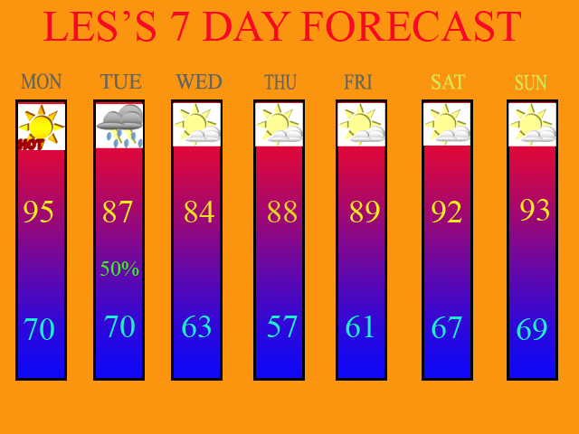
Well folks, I would like to start off by wishing all of the Dad's out there a Happy Father's Day! It was sure a hot one for Dad! CVG got up to 94 yesterday and I recorded a high of 96.2 degrees at the Weather Office in Burlington, KY. More of the same can be expected today as well before Tuesday's cold front moves through.
The models have been in decent agreement both yesterday and this morning on bringing the cold front through the region Tues. afternoon and evening. I think we stand a chance at some showers and storms Tues. morning before the front's arrival, but the best chance still will be with the cold frontal passage. Here is the 0Z GFS model run image valid at 45 hours, which is 5pm on Tues.

As you can see by the precip. legend, the dark blue area generates only around a quarter of an inch of precip. for the region. Some areas will see less, and some will see more wherever a heavier T-storm occurs. This is only an average as depicted by the model.
As far as any severe weather threat goes, slim to none at this point, especially if we get any morning convection. I have posted the SPC's severe threat probability map for tomorrow, which gives us only a 5% chance. The main threat will be damaging winds, but again, the threat is very low.

As we progress through the rest of the week, dry weather will build back in on Wed. High temps. will be nice on Wed. with a moderating trend back into the 90s by the weekend. There could be another front trying to push Southward into the region from the Great Lakes by Sunday, but the latest models are showing the majority of the moisture to remain to our North at this time. Thus, my 7-day only shows Tuesday's threat of rain. I will update it, of course, on my next blog entry. The forecast is valid for June 18th thru the 24th.

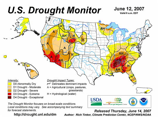
Next, I give you the latest US Drought Monitor map which was released on Thurs. of last week. Notice how the drought continues to expand Northward as well as the D2 (Severe Drought) area. I think areas from I-70 on South will be in a D2 status when this Thursday's update comes out.

Long Term Outlook (June 25th thru July 3rd)
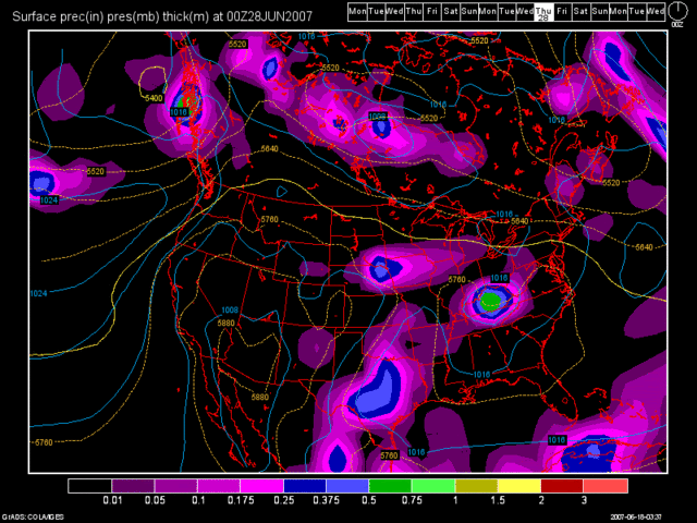
In regards to our long term outlook this go around, more of the same can be expected. Another huge dome of high pressure is expected to develop in the SW states and then expand Eastward into the Plains and OH Valley as time goes by. This will keep the drought alive and well. The only possible drought relief that can be expected as long as this type of weather pattern continues is if we can get a weakness in the high pressure ridge where MCS's (Meso-scale Convective Complex) can develop and track our way. The 0Z GFS shows one of these situations developing. However, since it is 240 hours out in time, we can not bank on this feature actually occurring. But, it gives us something to look forwards too, right? The below image is for June 28th.


No comments:
Post a Comment