As of this blog entry, the Burlington Weather Office is reporting a T-storm with a temp. of 84.6 degrees. Precip total: 0.04". CVG today picked up 0.11" Below, you will see a GR Level 3 Radar image as of 8:20pm, when the first drops began to fall at the Weather Office.

As predicted, we have definitely have seen some dangerous heat across the region this week. That will continue for one more day. The 12Z GFS MOS Guidance has 101 for tomorrow. I am forecasting 100! Today, CVG hit 100 officially for the first time in 8 years! The last time we hit 100 was July 31st, 1999. We also broke a record high, which was at 99, set back in 1999. Below, is the public information statement, which was released by the NWS in Wilmington, OH.
... Record high of 100 degrees set at Cincinnati...
The temperature at the Cincinnati-Northern Kentucky International
Airport reached 100 degrees at 258 PM today. This broke the record
high for the date which was 99 set in 1999. This also Marks the first
time since 1999 that the Cincinnati Airport reached 100 degrees. It
is possible that the temperature will rise even higher later this
afternoon.
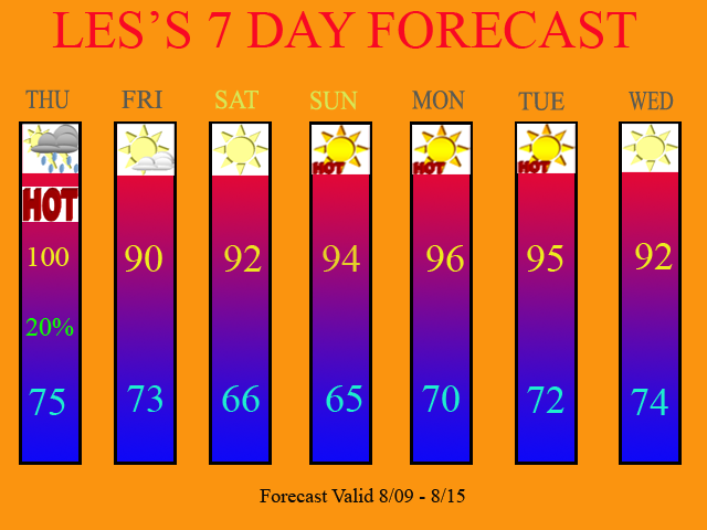
At the Burlington Weather Office, I recorded 102.4 yesterday and 104.8 today! I also expect tomorrow to be day 3 in a row for Burlington with 100+ degree temps! Tomorrow will be our last day for triple digit heat. The ridge of high pressure, which has been dominating our weather, will retrograde off to our West. In doing so, a stationary front, which has been producing heavy, flooding rains in Southern MI, Northern IN, and OH, will finally sag far enough Southwards by tomorrow afternoon and evening, that isolated T-storms will be possible across the region. The 12Z GFS keeps most of the moisture to our North. Thus, I have inserted 20% POPS for tomorrow. Here is the 12Z GFS model image valid at 18 hours.

Afterwards, we will briefly drop below the 95 degree mark. In fact, on Friday, we will struggle to even hit 90 degrees! The record at CVG for the most consective days of 90 degree temps. stands at 16 days. We are currently on Day 10 counting today. If Friday turns out to be a 90 degree day, then our record could be threatened! WOW... amazing stuff! Record heat and drought-like conditions! Being that you guys are blog readers, you heard it here! Way back in the Spring, I predicted a hot and dry summer. Besides July being cooler then avg (but below normal in rainfall), my summer seasonal forecast has been right on the money!
The weekend will continue to offer dry conditions, with temps. once again approaching the mid 90s by Sunday. The ridge of high pressure will re-build over the region for early next week. This will continue the hot temps. and dry conditions across the region.
Now, the 12Z GFS does try and bring a front thru on Monday, but notice in the below image, again, all of the moisture is to our North. Thus, I am leaving Monday dry at this time.

Below, you will see my updated 7 Day Forecast.

Long Range Outlook (Aug. 16th thru Aug. 24th)
The 12Z models call for more of the same. The ridge will continue to dominate and only slightly weaken from time to time, allowing for 20-30% coverage of storms, maybe once or twice a week. The 90s will most likely continue during the next 2 weeks as well. The drought will likely worsen and on tomorrow morning's Drought Monitor Map, we should see that be the case. I expect the D3 area to probably return to Southern KY, and the D2 area should expand in our area as well. The next DM Update on Aug. 16th should show my prediction quite nicely if it does not occur with this week's update. Check the USA Weather Forum after 9am tomorrow morning, and I will post the new map for Aug. 9th in our Drought of 2007 Section. The website is: http://www.createforum.com/usaweather

2 comments:
Looks GREAT, Les! Very Professional! :)
Thank you Trev! I always appreciate feedback... especially when it's positive! =)
Post a Comment