I have lots to discuss in this morning's blog entry, so let's get to it! We had a nice day yesterday with much less humid conditions. For today, high pressure will remain in control keeping the dry weather going. Areas that could get a storm by this afternoon and evening will be well North of the Tri-state.
Now the fun begins for the Fri and Sat time period. The models have been performing terribly ever since the drought developed over the OH Valley. They tend to over estimate our precip. and they also have been too cool with temps. Take Tuesday's system, for example. Most areas received less then 0.25" and some received a trace to nothing at all. (Like the Burlington Weather Office, and CVG, which only picked up 0.03"). I think for Fri and Sat, it'll be a similiar situation. Some areas could get over an inch, but most I think will be under 0.25" and other areas could get nothing once again.
The reasoning for this poor performance is because of the drought. In many areas of the region (especially in Northern KY), we lack ground moisture. When we lack ground moisture that the T-storms use to feed off of, it is harder to get wide spread, soaking rains to develop. Also due to our low humidity values, which we have seen for the most part since the drought began, the atmosphere is able to heat up more rapidly. Also, with the dry air mass in place, the smog and haze tends to be less of a factor as well. The computer models only generate an avg. in regards to precip. coverage. It is impossible for a model to predict exactly where a T-storm may develop. It can only provide a general area where T-storm development is favorable. Keep all of this in mind as I continue to discuss the models and when you look at the 7 Day.
I believe that the models are busting on the position of the cold front, which is going to be dropping down from the North. This will be a key factor in the forecast and also it will dictate who gets soaked and who gets ripped off! Look at the current Sat. Pic. below:

As you can see here, the front is currently located in the Northern Plains region and the Upper Midwest. That's pretty much where it was located yesterday afternoon as well. In fact, Severe T-storms are still pounding those areas. Watches, as of this post, currently extend from the Dakotas into MN. I am leaving the 7 Day dry today because the models are forecasting the front to be in either Northern or Central Ohio by this evening. I disagree with the front being any further South then that for today.
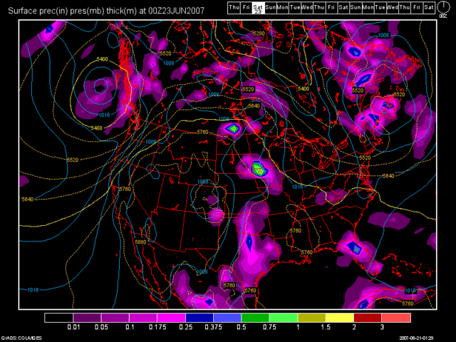
Once Friday rolls around, the 0Z NAM model has really gone crazy with T-storm (MCS) development. Look at this image valid at 48 Hours! (Sat. morning at 2am)

This model run is totally out to lunch! I mean, for starters, the NAM model is known for over developing systems anyway, and as I stated above, the trend has been for the models to do just that since we have been in this drought. So, with that in mind, I am totally disregarding this model solution and I am throwing it out the window!
Next, let's take a look at the 0Z GFS model run valid for the same time period as the NAM.

This model run is much more realistic. It shows the T-storm complex already by us, and another one developing in Southern MN/Northern Iowa. Also, the T-storm complex weakens as it heads our way. I think that the GFS though is too quick with moving the front through. In my 7 Day I have used a blend of the NAM and GFS model solutions, favoring the GFS with precip. coverage.
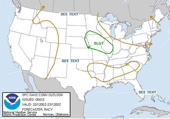
The SPC has backed off on any organized MCS development and severe weather potential for the Tri-state. Yesterday morning, we were in a slight risk. Yesterday evening, the slight risk shifted further North. Now look at the SPC's Day 2 Outlook, which would be for Friday. It shows the best chance of T-storms to the SW of us.

I am not going to post the Day 3 Outlook, for Sat., as it is fairly similiar as the Day 2 Outlook.
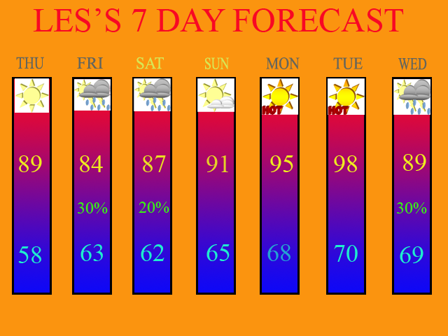
As far as temps. are concerned, if my forecast is correct, the temps. should work out just fine. If I bust, then the temps. will be much lower for the Fri. and Sat. time period. For Sun., I have left the forecast dry, because I feel that T-storm development is unlikely at this point. If anything, we may see a slight risk of a storm early Sunday morning (before 8am), but I left the 7 Day dry for Sunday at this point. Temps. will be beginning to heat up as well.
As we begin next week, the hottest air of 2007 will be moving into the Tri-State. The models are in really good agreement with the massive Ridge of High Pressure that is currently baking the Western States, expanding Eastward into our region. I went with temps. in the mid 90s for Mon. and upper 90s for Tues. My reasoning for this is because if we see little or zero rainfall on Fri and Sat, then we have no ground moisture to hold the temps. down. In other words, the humidity will be low, and the air mass will be dry. This will allow temps. to skyrocket. In fact, when I do another blog update and 7 Day update early next week, I may insert a 100 degree high temp. for Tues! If we see a decent rain on Fri. and Sat. then low 90s on Mon and mid 90s on Tues would be the case.
For Wed. of next week, the high will begin to move off to the East, and finally, there are signs that a Bermuda High type of weather pattern could be developing. I have thus, inserted a chance of storms at the end of the 7 Day, due to the fact that a moist SW flow should be developing by then. This will increase the humidity in our atmosphere as well as allowing for afternoon pop-up storms to develop in the afternoon. This is more typical of summer in Cincinnati, then what we have been seeing over the last month and a half. I probably am a shade too low on my high temp. for Wed, especially if the return flow doesn't kick in, until Thurs. Mid 90s are probably the way to go and I'll have to look at the models again when it comes time for me to do another update early next week.
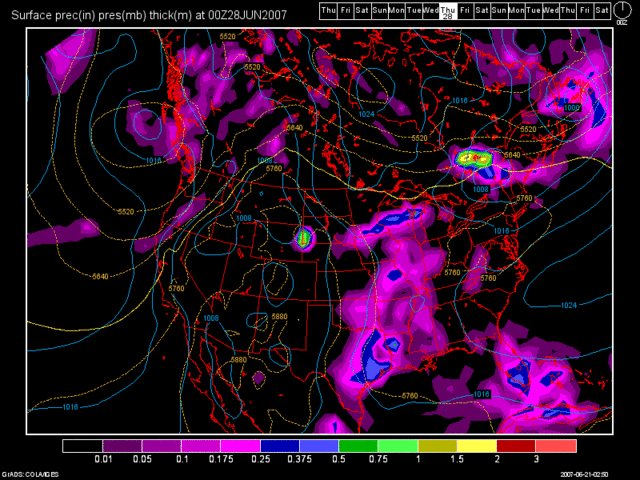
Here is the 0Z GFS model run valid at 168 hours, which is for Wed. of next week. You can clearly see the return flow that I am talking about.

Below, is my 7 Day forecast valid for June 21st thru June 27th.

Long Term Outlook (June 28th thru July 6th)
Due to the Bermuda High type of weather pattern developing, we will be in a moist SW flow pattern, assuming the GFS is correct anyways. Therefore, as of this blog entry, a daily chance of afternoon storms would be possible thru July 1st with dry conditions thru the remainder of the long term period. High pressure looks to re-build over the region during the second half of the period.

2 comments:
I certainly hope you are right about Saturday. I would love to get dry temps, until at least 3 or 4 pm.
Yeah... models are all over the place, but as you saw by my blog entry, I'm going against the models. I'm either going to come out as a genius or a fool.
Post a Comment