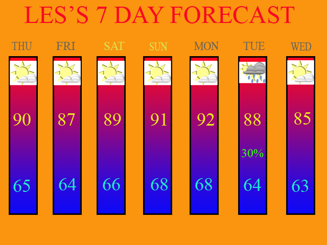
Before I get into writing this blog entry, I'd like to start off by thanking two of my closest friends, Nick Nonno and Anthony Torres. These two fine gentlemen assisted me in developing a 7 Day Forecast graphic for the Blog using Adobe Photoshop. Nick gave me guidance on how to create the graphic, and Anthony supplied me with the forecast icons. KUDOS to you both!!!
Yesterday afternoon, there was quite a bit of shower and T-storm development, mainly to the North and East of the Cincy Metro area. Some of the storms were severe as well. They contained brief heavy rains, gusty winds to 60mph, and also small hail up to 1" in diameter. I think a similar situation will unfold this afternoon and evening as well. However, a better chance does exist for the Tri-state then yesterday, as the upper level low off to our East, is a little closer to us today.
The 0Z GFS model run really isn't painting much precip. over the region at all. The 0Z NAM, however, is showing some decent coverage for the Tri-state. Below, you'll see the 0Z NAM model image valid at 21 hours.

I think the NAM is way overdone here. The models have not done all that great of a job with the weather pattern over the last several weeks in regards to T-storm development and coverage. I'm going to side with the 0Z GFS for today's forecast. Although the entire Tri-State area today could see a T-storm, I still feel that the best coverage will be to the East of Cincinnati, as it was yesterday. As a matter of fact, areas to the South and West of Cincinnati only stand less then a 20% chance of getting anything at all. Therefore, due to that low of a chance, my 7-day is remaining dry for today.
Dry weather will continue during the Fri. through Mon. period as the upper level ridge builds back into the region. This will cause our temps. to warm into the low 90s by Sunday and Monday. If you look at my 7 Day, which I will post in just a second, I may need to bump up my high temps. a few degrees for Sun. and Mon. if the ridge gets stronger then what the models currently are indicating. But for now, it'll work.
A cold front is still scheduled to move through next week. The models are pretty much in good agreement now with it coming through on Tuesday, June 19th. They are in disagreement in regards to coverage though. Below is the 0Z GFS model run valid at 144 hours.

In my 7 Day, I'm only going with a 30% chance of precip. (POP) at this time due to model uncertainty. I'll either raise or lower that POP as future model runs dictate.
Here is my 7 Day Forecast valid for 6/14/07 - 6/20/07 :

Long Range Outlook (June 21st - June 30th)
Models are in disagreement with what happens during the last 10 days of the month. Behind Tuesday's front, cooler air will be moving into the region, as you can see by the 7 Day Forecast for Wed. The question of the day is this... Will the trough stay in place or will a ridge re-build itself over the Midwest? Below, I am going to post two more model images from the 0Z runs. The first will be the Euro. It is showing the top of the ridge being flattened just a bit, with the trough pretty much staying in place.
0Z Euro Valid at 168 Hours

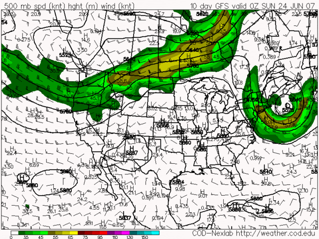
The next image will be of the 0Z GFS. It shows the ridge re-building and basically a repeat of our current weather pattern with the ridge over the Midwest and the trough over New England. Check out that big low pressure system off of the New England Coast again. It certainly looks like a repeat of what's been going on this week, doesn't it?
0Z GFS Valid at 240 Hours

At the present time, I will side with the 0Z GFS and not the Euro. I think that the weather pattern will repeat as it's been doing for the last month and a half. In fact, at the Airport (CVG) we are running 5" of rain below normal since May 1st. I say "we" since that is where the official records are kept for the Cincinnati Tri-state area. I look for that trend to continue, especially if the 0Z GFS model is correct. In my next blog entry, I'll post the updated US Drought Monitor map, which will come out around 8am this morning.

2 comments:
It looks WONDERFUL Les!
Angela
Why thank you, Ang! =) I finally finished it around 11pm last night.
Post a Comment