I have lots of graphics and information to share with you in today's blog entry. I'll start out by discussing the severe weather threat for today. Then, we'll move on and talk about our beautiful weekend! I will then end this post by talking about the drought once again.
Severe WX Threat
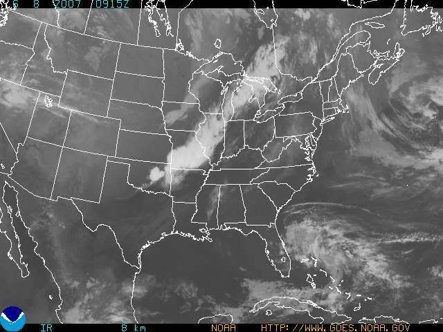
I've been watching the computer models over the last couple of days and our severe wx threat was looking pretty good, but as has been the case all season long, as the event draws closer, the threat diminishes greatly. I think that for today, it'll fall into that same category. I'd like to start off by showing you a current sat. image and radar loop image from the Central US.

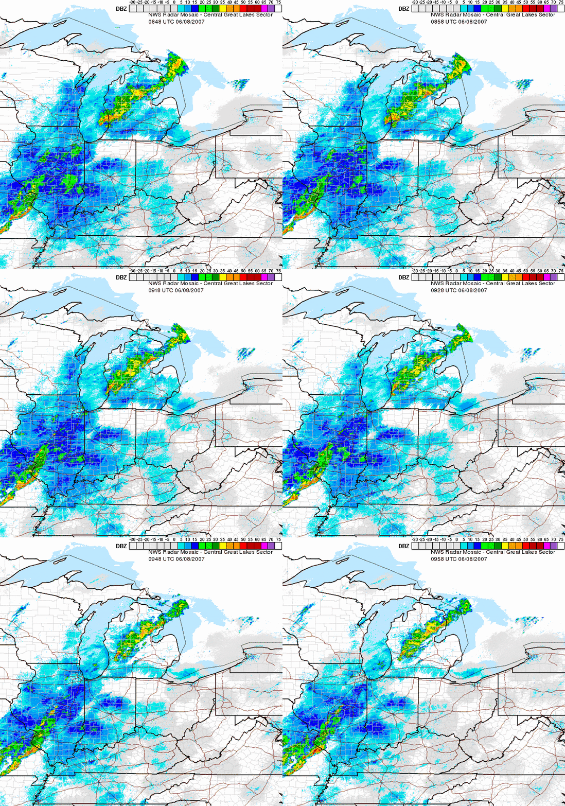
You can clearly see where all of the action currently is. Now, here comes the radar loop, so you can see where the Storms are at (as of this post). NOTE: All of that activity over Indy and Ohio is known as ground clutter, so just ignore it. Those are false radar returns. The action is over Michigan, Illinois, and Missouri at the present time.

By looking at the radar loop, you'll notice that none of the storms look all that impressive, and they continue to weaken as they head in our direction. This is due to the time of day that it is, since the sun is just starting to come up now as I write up this blog entry. Also, that darn SE Ridge that I've been talking about since May has also been weakening storm systems as they head into the Tri-state. The SE Ridge is also the cause of our on-going drought. More on that later.
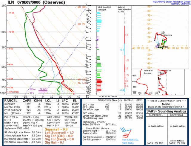
The next image that I have for you is the Soundings from Wilmington, OH. (ILN) This graphic is very complex and hard to understand. It took me a while to figure out a lot of what it meant. But basically, it is showing us the dynamics that we have in the atmosphere over the Tri-state today. I'll post the graphic first, then I'll talk about it.

I'm not going to go into a whole lot of detail as to what everything means here, but I'll point out a few things. Don't worry about the lines on the charts too much. I basically just look at the boxes below that. I'll type out below, the numbers and then give you my prediction for today based on that. I did shrink the image down somewhat, and on some monitors it may look like the image is cut off, but hopefully you can see the two boxes underneath the charts.
Surface Based CAPE: 1237
CIN: -6
Lifted Index (LI): -2
Wet Bulb (WBZ): 9 ft.
In the middle box, that is where the shear information is located at. Those numbers are in knots.
So, based on the above information... we have moderate instability going for us today. The lift in the atmosphere is not all that great. The value is at -2, and I'd rather see it above -5. A small large hail potential as the WBZ is at 9 ft. The shear is decent though, so at least we have that going for us. The main threat from any storms that we may get, will be damaging winds. I don't have the time currently, to post any GFS or NAM model images as I usually do, but both 0Z runs are in decent agreement showing the activity arriving late morning or early afternoon. In my opinion I think early afternoon is probably the best timing that I can give you at this point. I think a few storms could turn severe, but as far as a widespread event goes, I don't think it's going to happen. It'll be a warm and humid day though as CVG is still sitting at 78 degrees as of this post, so we'll have no problems getting into the middle and upper 80s today. If the cloud cover holds off longer then expected then 90 degrees is possible and the severe wx threat would increase just a bit. However, as I have said before, due to the strong SE Ridge that has been in place since May, I think that is going to kill our chances of getting any widespread action. I think that the coverage of the rainfall will be anywhere from 40-60%.
Weekend Forecast:
After the front passes thru this evening, drier and less humid air will move into the region. I expect highs near 80 on Sat. and in the lower 80s for Sun. Get outside and enjoy this great looking weekend folks, as the heat will return next week.
Next week:
As the Ridge re-builds and dominates our weather once again, we can expect dry weather and moderating temps. once again. I think temps. will reach the middle 80s Mon, upper 80s Tues, and 90 or so by Wed. and Thurs. Our next real threat of rainfall should be Wed. and Thurs. afternoon, but again, that will not be widespread at all. That activity will be the usual summertime pop-up storms, so good luck getting anything in your backyard.
The Drought Intensifies:
As for the drought, here is the latest map below:

Notice how the D0 and D1 areas have expanded Northward. Most of the Tri-state region is in a D1 status now, which means that the drought is Severe. Again, I apologize for not having time to post more model graphics, but both the 0Z GFS and 0Z Euro models runs both agree on keeping the SE Ridge in place, and the storm track running from the Pacific NW, into the Northern Rockies, then into the Upper Midwest. This spells bad news for us. I am also going to make a bold prediction here. If this pattern does not change, then by mid July or so, I think the D2 area on the Drought Map could sneak into our region of the country. We shall see how it goes, but it's not looking good for our gardens and lawns this summer.

2 comments:
GRAPHICS ARE DISPLAYED MUCH BETTER. I can actually see where I live now. Very well done.
Good! Thanks for letting me know. It took me a while to figure out the resizing using Photobucket to post the images with into the blog. I'm glad it's working properly now. Also, I figured out how to tinker with the HTML code a little bit too, which I think is helping.
Post a Comment