Yesterday's system delivered more rain and some severe wx, which I was not expecting. The NAM overall was closer then the GFS with this event. The Tri-State as a whole though still needs rainfall. CVG did not pick up anything from the event, and only recorded a Trace of precip. I'd say 65 or 70% of the Tri-state did not get anything yesterday at all.
I apologize in advance, but there will be no 7 Day forecast graphic with this blog update. Instead, you'll be reading the text version of it. Unfortunately, I have not had time to update the graphic. I am at my Branch Weather Office in Oregonia, OH, all this week, so I don't have a lot of the tools and goodies that I would be using at the Burlington Weather Office. Plus, I've been busy anyways.
This week's weather will be characterized by a trough over the Eastern Great Lakes on into New England and the huge heat dome of high pressure will remain out West. The OH Valley will be in between the ridge and trough, thus causing us to be caught in a NW Flow aloft. This will feature weak disturbances diving out of Canada bringing us a daily shot of rainfall.
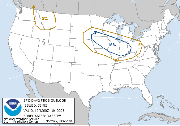
The SPC even has us in a slight risk for Tues. and Wed. in regards to severe weather. Here is the Day 2 Probability Map:

The best chance though for rain this week, looks to be Thurs. night into Friday as the 0Z GFS shows an MCS riding along a cold front that is moving from N to S through the region. Here is a model image valid at 102 hours. (Thurs. night at 2am)

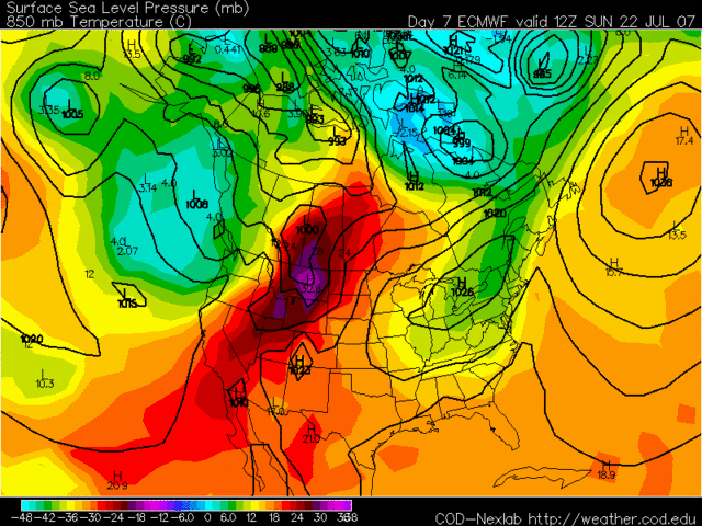
This coming weekend looks to be dry at this point as high pressure and cooler temps. move into the region. I think the Euro model illustrates this idea well. Here is an 850MB Temps. model image valid at 168 hours. (Sunday July 22nd)

Here is the text version of my forecast for this week. The forecast is valid for July 16th thru the 22nd.
Today - Mostly sunny. Highs around 89.
Mon. Night - Mostly clear. Lows near 70.
Tues - Morning sunny in the morning followed by increasing clouds in the afternoon. A 20% chance of T-storms in the afternoon. Highs around 90.
Tues. Night - An evening T-storm otherwise becoming partly cloudy. Lows around 71.
Wed. - Partly cloudy. A 30% chance of T-storms. Highs near 88.
Wed. Night - An evening T-storm otherwise becoming partly cloudy. Lows near 70.
Thurs - Mostly cloudy. A 40% chance of T-storms. Highs in the around 85.
Thurs. Night - A scattered evening T-storm, then a 50% chance of thunderstorms after midnight. Lows near 67.
Fri - A 50% chance of T-storms, especially in the morning. Highs around 80.
Fri. Night - Clearing skies. Lows around 63.
Sat and Sun - Mostly clear. Highs near 82 and lows around 60.
Long Term Outlook (July 23rd - July 31st)
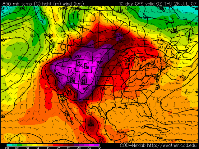
The long term period looks to be dominated by High Pressure, as the GFS Model tries to expand the heat ridge that is going to remain out West all week, into the Plains and maybe even parts of the Midwest. Here is the 0Z GFS model image of 850MB temps. valid at 240 hours. (Thurs. July 26th)

As you can see, look at how much of the country is under warmer temps. now. You can also see a trough entering the Pacific NW, thus forcing the heat ridge to expand further Eastward.
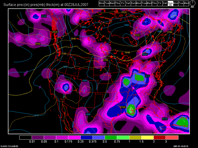
The only real threat at any widespread rains comes towards the end of the long term period. The GFS will probably weaken the system in time, but for now, here is another 0Z GFS model run image valid at 312 hours. (Sat. July 28th at 8pm)

As we end July and start August, another possible heat ridge could affect the region for the first week of August. The drought will worsen as I have been saying for a long time now and if both heat ridges impact our region, as some model data suggests, then watch over the next several weeks as the Drought Monitor Maps come out each Thursday. You will see the D2 (Severe Drought Category) encompass more and more of the Tri-State. Almost 60% of the state of KY is in a D2 status or higher as of last week's update. Here is the map for KY:


No comments:
Post a Comment