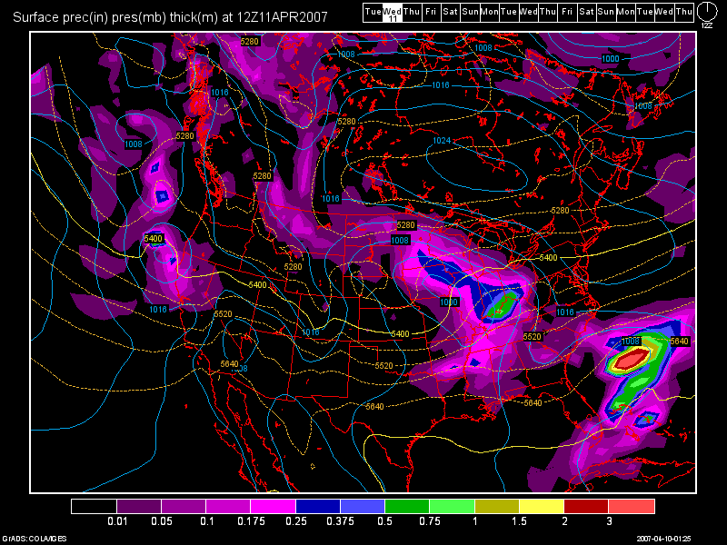
Wet times are ahead folks. The first system that I have to talk about is still our midweek system. To me, it looks like after midnight tonight, we should see some showers rolling in, with Wed. particularing looking like a washout at this point. The 6Z NAM model run shows about a third to perhaps a half of an inch of rain with this system, while the 0Z GFS shows about 3/4 of an inch to perhaps an inch in spots.
Here is an image of the 0Z GFS run valid at 36 hours, which would be Wed. morning at 8am.

In my last blog entry, I talked about the system ending as some wet snow Wed. night and early Thurs. morning. That is no longer going to be the case. The precip. will remain all rain with this system. Instability also looks to be very poor, so no T-storms this go around, just a general moderate rainfall event. Highs today will top out in the middle 50s and in the lower 50s tomorrow.
Weekend System
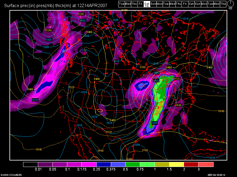
We'll see the action taper off Wed. night, or very early Thurs. morning. Highs on Thurs. should be in the 50s. For Fri., we'll see an increase in clouds as highs soar into the lower to perhaps the middle 60s depending on how much sunshine we get. I look for another system to get in here Fri. night with the rain chances increasing during the day Sat. Highs on Sat. should again be in the 60s, but that will occur ahead of the cold front, then fall during the afternoon back down into the 50s. some general T-storms appear to be possible, but no severe wx is expected. Again, this system looks to bring a half an inch of rain or better to the area.
Below, you'll see the 0Z GFS model run valid at 108 hours, which would be 8am Sat. morning.

High pressure should build back in for Sun. although it'll be a chilly day with highs struggling to hit the 50-52 degree mark.
Long Term Outlook: (April 15-25th)
In previous blog entries, I have talked about a secondary cold snap coming around the 19th or 20th. This no longer looks to be the case, as the model runs from the past 3 days have pretty much taken it out. We might finally be done with the bitter cold and snow that we have seen as of late in the OH Valley. Temps. look to avg near normal for the period, with some temps. slightly below normal at times. Highs in the 50s and 60s look to be the rule for the most part. Precip. wise, the GFS does not show nearly as much storminess as it once did. It shows a weak system for the 19th, and a better looking system around the 23rd and then towards the end of the long range period, a heavy rain event appears possible. At this time though, it keeps the big time precip. to our SW over the Missouri Boothill region.

No comments:
Post a Comment