Mother Nature is certainly going to be playing an April Fool's Joke on the Eastern US, in the coming days. First though, we have a severe wx threat to deal with. Before we get to that though, we certainly have some delightful weather conditions for tomorrow and Tues.
Opening Day Forecast:
I think we'll see wall-to-wall sunshine and breezy SW winds for the game. Wind speeds should avg. 10-15mph with high temps. around 74 degrees! On Tues., we'll see increasing clouds late in the day with temps. forecasted to be in the mid 70s with 76 degrees respectively being forecasted by the GFS model. I'm going with 81 degrees as I think the clouds will hold off until late in the day.
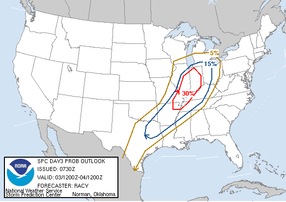
Check out this image below. This is the Day 3 Outlook from the SPC:

As you can see by this map, the highest risk area is just off to our West. That is because the models are not pushing the front through until after midnight Tues. night. If we can speed up the frontal passage by 3 or 4 hours, then we'll be in business for some severe T-storms. Right now, I think with the front coming through at night, the storms will be more linear in nature with a squall line moving through between midnight and 2am.
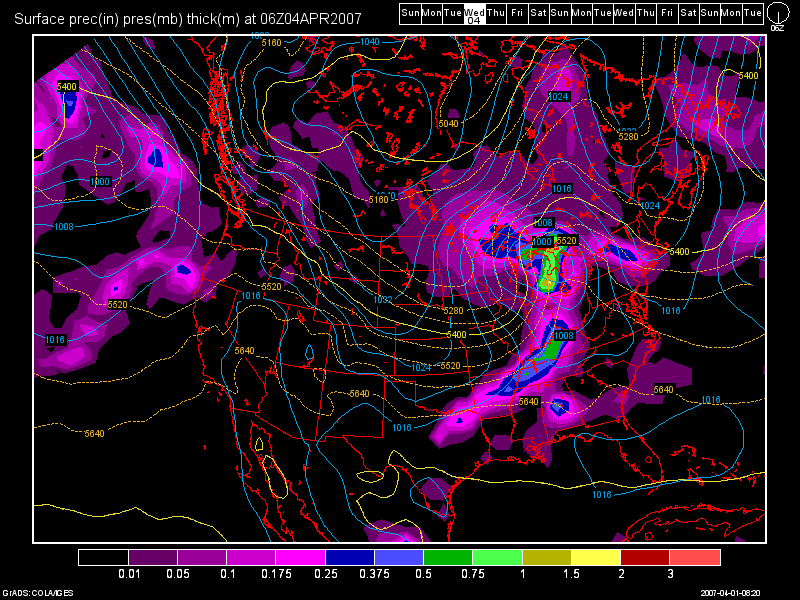
Below, is a model image of the 6Z GFS. It shows the squall line moving through around 2am.

The biggest concern to me is timing. The models show some nice deep upper level wind shear and moderate instability with temps. in the upper 70s to lower 80s in the afternoon and dewpoints rising into the lower 60s. However, the front may be too far out to the West yet to deliver us with major severe weather. If the front does speed up though, then we'll be under the gun. I'll continue to monitor this potentially dangerous weather situation.
Major Cold Air Outbreak Coming:
Behind the cold front, temps. stay steady or slowly fall on Wed. We'll see mostly cloudy sky conditions as well with temps. around the 50 degree mark. I can not rule out an isolated shower or sprinkles as well. By Thurs., the cold air will be pouring in with highs stuck in the 40s. I see the 40s continuing into the beginning of the next work week, April 9th. Lows through the period will start out into the lower 30s for Thurs. morning and dropping into the lower and middle 20s through the remainder of the period. Sky conditions should be a mixture of sun and clouds with a few light sprinkles or flurries possible from time to time. Mainly though, the big weather story here will be a ridge out West and a deep trough over the Eastern US. The Great Lakes region may even need to brace themselves for a clipper system (April 8-9th) which could bring a light snowfall to the region!
Long Term Outlook: (April 10th - April 17th)
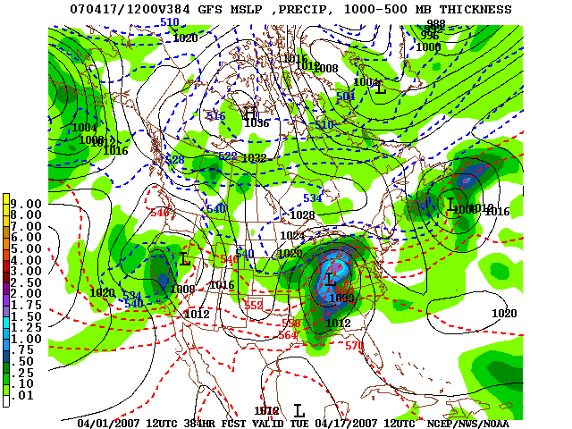
A couple of weak weather systems to start the period as the cool weather pattern continues to linger. At the end of the long-term period, the 12Z GFS shows a nice storm system moving through. See the image below:

As one can see, a low pressure system looks to track right through the OH Valley with around an inch of rain possible. After this system moves out, the cold pattern will break down and a wetter and stormier pattern looks to redevelop once again.
I'll continue to monitor the severe wx threat for late Tues. and Tues. night. Stay tuned to this blog, and the USA Weather Forum for further updates.

4 comments:
I think the best threat of severe thunderstorms especially supercellular will be in southwest Indiana, South central Indiana, and down into western ky. Timing is huge and both the GFS and the NAM bring the front in 4 or more hours after we lose heating. However a mitigating factor is that once the mid-level flow becomes unidirectional with everything else, the linear line will have some bowing and some vertical shear left in it. Now whether that makes it to Sw Ohio before midnight will be key. I do believe it will be too late for us as far as the line goes. Now there is a minimal threat that we could see a few frontrunning supercells out ahead of the front but mainly in SE Indiana. Should be interesting to watch!
Excellent analysis Rich! Thanks a lot for leaving a comment! I hope to have high speed access finally here in about another week! So once severe wx season really kicks in, I'll be ready to help out the team a lot better :D
Great post Les! I agree as always. Love the pictures by the way!
Thanks Nick very much! I'm glad you and everyone else are enjoying these posts. I really enjoy doing them and I appreciate the positive feedback!
As far as the pics go, I finally got a Photo Bucket account. Links just don't do it justice. I much rather enjoy showing a visual aid when I want the reader to understand a point or topic that I am talking about.
Post a Comment