Good morning everyone!
We have little to discuss in our weather in terms of rainfall or severe wx, so this blog will be discussing what's going on around us, and the long term implications that could be in our future.
Subtropical Storm Andrea is the first named storm of the 2007 Atlantic Hurricane Season. This system is a hybrid of sorts because it is not a warm core system as most tropical systems are, and it's not a mid-latitude cyclone, which are the kind of storms that we see here in the OH Valley. Therefore, it's called a Subtropical storm. Winds are still around 45 mph and the system is still spinning and slowly drifting to the W and SW off of the SE Coast. The models are forecasting the system to keep slowly drifting eventually more to the SW over the next few days. It's going to be a while before it's totally gone. Not much rain is falling in the fire ravaged areas of Georgia and Florida. It's actually creating more of a problem due to the strong E to NE winds on the Western side of the storm. These winds are dry winds and they are fanning the flames and making for awful conditions for fire fighters.
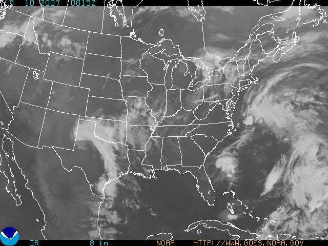
This system actually does affect our weather in a more indirect sort of way. We are sandwiched in between Andrea and a system out in the Plains. As has been the case for the last couple of weeks, the cold fronts weaken, if not totally die out, by the time they move into the OH Valley. This is caused by the strong ridge of high pressure that continues to dominate the Eastern US. Look at this morning's Satellite Imagery, and you'll see what I mean. There is a major lack of cloud cover over most of the Nation.

In regards to our rain chances that I talked about in my last blog entry, those chances are diminishing with every future GFS model run. In fact, we stand about a 10 to maybe 20% chance of seeing a spotty shower or T-storm for this afternoon and early Friday morning. Most areas will remain dry. Highs will continue to be above normal, in the lower to middle 80s. Normal highs for this time of year should be around 72 or 73 degrees.
Another strong high pressure ridge will drop down from the Great Lakes and dominate our weather thru early Tuesday. Highs this weekend will be in the middle 70s under sunny skies! We'll see low humidity values as well. Even though we need the rain badly around here, you couldn't have asked for better weather for Mother's Day! On Monday of next week, highs will moderate back into the 80s once again.
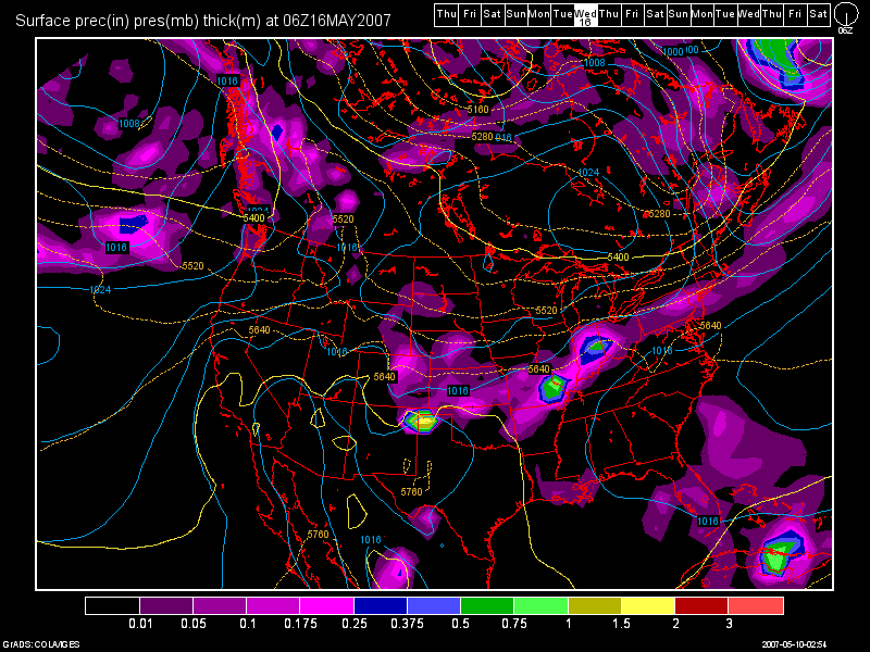
By Tues. of next week, this is the best chance of rain that I can find for the next 10 days or so. Remember my last blog entry, where the 3rd week of May was looking stormy? Not anymore folks. As stated above, the GFS runs show strong systems 7-10 days in advance then after a few days, the models weaken the cold fronts considerably. That model trend will continue as long as the ridge continues to dominate our weather, which I believe it will. It looks like our best chance will come Tues. afternoon and into the overnight period. Even then, I'd only say 50% coverage at this point. The GFS may even continue to weaken this system further. I'll continue to monitor. But for now, here's a look at the 0Z GFS model run valid at 150 hours (Tues night/Wed. morning at 2am) :

Long Term Outlook (May 15th - 25th)
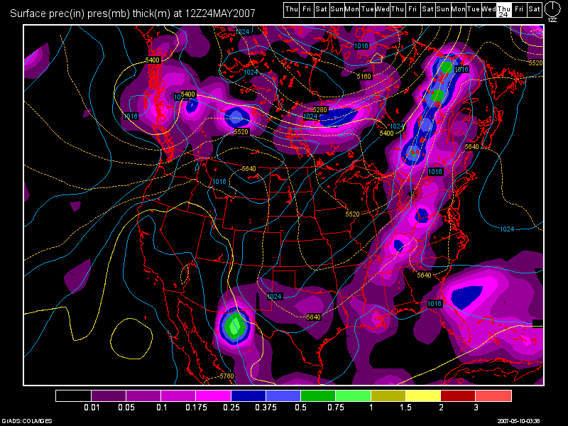
After that system moves out, there is NOTHING, and I mean NOTHING to really talk about. I continue to see above normal temps. and a ridge of high pressure continuing to dominate our weather pattern. The next system I could find is scheduled for the May 23-24th time frame. We all know that the GFS will probably even weaken this system too in time. But, here is the 0Z GFS model run image valid at 348 hours (Thurs. May 24th at 8am) :

Is there a potential drought developing?
The simple answer to that is, YES! I think that the chances for a drought are increasing rapidly with each passing day. We have had only .14" at CVG for the month of May and .10" at Dayton. The month of May is our wettest month of the year at over 5" for CVG. We will come no where near that! We are running behind in the rainfall dept. as one can clearly see. If we do not receive any widespread rains in the next couple of weeks, then be prepared for a drought, and a long, hot summer. You heard it here folks! That is my prediction at this time. I see no shift in this weather pattern at all. The ridge will continue to dominate the Eastern US. In fact, the Upper Midwest, Great Lakes, Ohio Valley, SE US, and New England are all running below normal in the rainfall dept. Numerous fires continue to burn in Florida and Georgia.
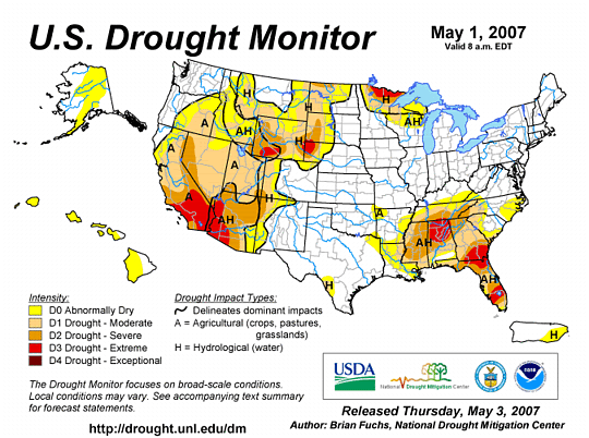
Below, I have posted the Drought Monitoring Map from the Climate Prediction Center. (CPC) This image was last updated on May 1st. As long as we remain in this weather pattern, I'll continue to post the map on the blog here from time to time.

Notice that currently, we're fine. We have not been classified as a drought area yet. But in another couple of weeks, if things do not change, then we probably will be. Notice that Southern KY is in the D0 status now. I again, do not see us getting any huge amounts of rainfall in the next few weeks.

4 comments:
Thats an Awesome Post Les! I really Enjoyed it!
Why thank you Martie! I always appreciate any feedback that people leave on the blog!
Our Tues. night/Wed. system to me, looks to be the only decent rains that we'll get in the next 2 weeks! If that system does not pan out, then we'll be in trouble.
More to come on my next blog entry which I should post Monday morning.
It has started to sprinkle here. The sky is very, very dark. Hoping it would hold off until after work, but looks like it is coming.
The Airport only picked up 0.14" of rain. Pathetic!
Post a Comment