I know that I have not updated the blog here in a long time, but we really have not had anything to talk about here in the Ohio Valley. Also, since I'll be on vacation, I wanted to get this entry in. Blog Updates will resume on or after June 5th.
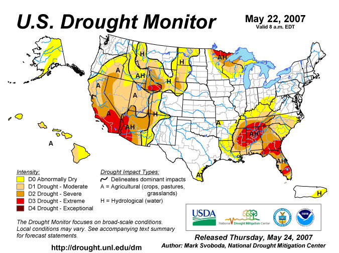
In the meantime, the drought continues to worsen across the Eastern US. The latest US Drought Monitor Map is posted below. Notice how the D1 area has moved into SE KY. Also, notice how the SE US is in desperate need of some rainfall. Folks... it's just NOT going to happen! Well, at least for the SE US anyways, unless some tropical activity gets going later on down the road.

For us here at home, a cold front continues to weaken and slow its forward progress. The Ridge that has been dominating the Eastern US will continue to do so. Therefore, I expect the front to NOT even make it this far South whatsoever until maybe Sun. night or on Memorial Day. I think today, most everyone will remain dry. The best chance to see any rain is going to be North of I-70. Highs should be in the mid to perhaps the upper 80s for today.
For the Holiday Weekend, on Sat., the front lifts back North as a warm front. I can not rule out an isolated storm, but 95% of the region will remain dry and see nothing. Highs again will be in the lower to middle 80s. On Sun., I think we do stand a better chance as the front comes South again. This time, we may actually get some better upper level support, so I am expecting probably about 30% coverage this time! Highs again, will be in the lower 80s. For Memorial Day, I expect a continued chance of storms with again, about 30% coverage, and highs again should be in the lower 80s.
At this time, I expect Tues to be dry. Another front will try and move in by midweek, so again, about a 30% chance at seeing a storm on Wed. and Thurs. with highs in the lower 80s for Wed. dropping to the upper 70s to perhaps 80 by Thurs. As you can see by reading this blog entry thus far, no widespread rains are expected. These are going to be your garden variety storms. If you get one in your backyard, consider yourself fortunate. Also, this will do NOTHING to help us out in drought dept. The rainfall from these type of storms comes quickly and doesn't last all that long, and with us having such dry ground now, the water will not soak in, but rather just run right off.
Long Term Outlook (June 1-10th) :
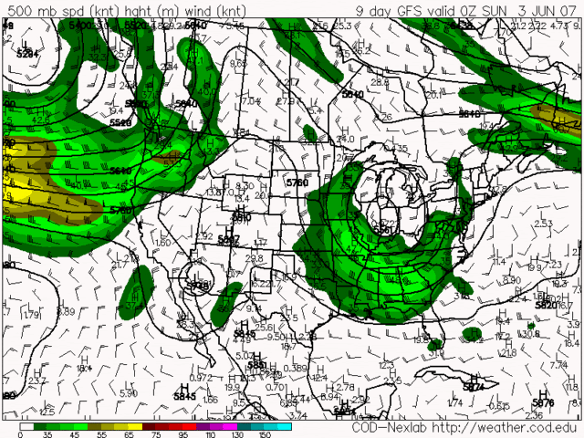
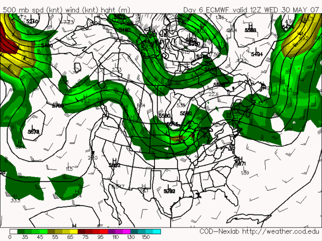
The models have been performing horribly as of late. They can not handle this type of weather pattern at all. The GFS is trying to develop a HUGE Trough over the Eastern US for the 1st week of June. I disagree with this model solution. The Ridge that we currently have in place will not give up the fight that easily. The GFS also has a bias of trying to change weather patterns too quickly. I've been watching this potential pattern develop over the last week or so. Some model runs, the GFS keeps the Ridge in place, and then sometimes it develops the Trough again. It has not been consistent at all lately. The Euro model, however, has been VERY
consistent. It never has shown a trough developing, and it keeps the Ridge over the Eastern US intact.
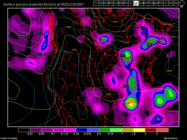
I have some more images to show you. The first one is the 0Z run of the GFS valid at 192 hours, which is June 1st at 8pm. Since the GFS is trying to develop the trough over us, check out this nice cold front that it shows plowing through the region.

Again, as I stated above, this model run is total garbage! I will show you why. Look at the next 2 model images. The first one will be the 0Z GFS run for Sunday, June 3rd. This is not the usual precip. map that I keep showing. This map shows the upper level winds at 500MB. It almost looks like a jet stream type of map. Notice the U-shaped configuration over the OH Valley. That is the Trough that it is trying to develop.

The next image is the same kind of map, but it's the Euro model (ECMWF). Notice how the ridge stays in place, and the Trough remains to our NW over Canada, the Northern Plains, and maybe into the Great Lakes. This map is valid at 144 hours, or May 30th. Looking even further ahead, the Euro still maintains the Ridge over the Eastern US into the 1st week of June.

I am definitely going with the Euro model for my long range forecast. It has been a VERY consistent model ever since we have been in this dry and mild weather pattern. Sure, there will be chances of isolated storms from time to time, such as what I talked about at the beginning of this blog. But, as far as drought busting, soil moistening, widespread rains, I just do not see that happening.
Have a GREAT Memorial Day Weekend everyone! Be safe, have fun, but most importantly, Support our TROOPS! They sacrifice a lot for our safety. If you know someone who is a Veteran, thank them as well!

2 comments:
we had a lil rain here over the holiday weekend not a whole lot tho...we had some thunder and lightning saturday I think it was...
I hope you are having a good time
I miss ya n will talk to ya when you return be safe!
I had a great time, Martie! Thank you so much! It's good to be back. Blog update coming up in the morning.
Post a Comment