Some parts of the Tri-state have received some decent rains this week from our cut off low that I talked about in the last blog entry. CVG though was one of those areas that did not. A total of 0.04" has fallen this week at the Airport. Florence, just a few miles away received around 0.25" today! Parts of IN and OH received well over an inch. So, as is typical with cut-off lows, the rains were locally heavy in certain areas, and light in others.
Now, we move on to the Front. The models are in very good agreement with the timing. I think the best chance for seeing widespread shower and t-storm activity will be anytime after 5pm tomorrow and probably by midnight or so we should begin to taper off in intensity and areal coverage.
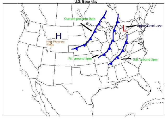
Here is a map that I have created which shows you my current thinking on the frontal position over the next two days.

If you look at this map, I have the upper level low, or cut off low depicted on this map by the red "L" over Canada/Upstate NY. That was the low that has been affecting us this week. Secondly, you can see the front as it progresses towards, and thru the area. Finally, the big "H" out West is where the big ridge of high pressure resides, and also where the intense heat has been for a while now.
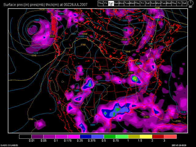
As far as amounts go, the models are generally painting a nice rainfall event for the region. Below, I have two models images to show you. The first is of the 12Z NAM run valid at 33 hours. (Fri at 5pm)

As you can see, it generates a good inch to 1.25" for the region. The next image is of the 12Z GFS, valid at 42 hours. (Fri at 8pm)

The GFS shows everyone getting some nice rains as well, however, the best chance of 1"+ rains appear to be North of the OH River with this model run, with areas to the South, such as Northern KY, only getting around a half to perhaps 0.75" of rain.
My current thinking is that everyone in the Tri-State should pick up a good half inch of rain out of this, on average, with isolated spots (North of the River) picking up amounts of 1 to 1.5".
As far as any severe weather goes, a few cells could turn severe out ahead of the front, and I think between 2 and 4 warnings could be issued for the Tri-state tomorrow, but that would be about it. Widespread severe weather is not expected at this time, even though we are under a slight risk from the SPC. To further support my claim, here is an image of the forecast soundings from the RUC model valid at 12Z, which is Fri. morning at 8am.

According to the RUC model that is posted above, the following severe weather parameters are in place as we start the day tomorrow:
Precipitable Water = 1.63" (Mod. to Heavy rain possible)
Wet Bulb = 6 feet (Large Hail Threat - Low)
CAPE = 752 (I'd prefer it over 1500 for severe weather)
Lifted Index = -3.5 (I'd prefer it at -5 or -6 at least)
Remember, this is as of 8am, so naturally, these numbers will certainly increase as the day progresses tomorrow. If we can get some sunshine in here, then we stand a chance at getting some severe weather. However, low level shear is weak and that certainly will be against us. Also, another limiting factor will be cloud cover. How long will that stick around tomorrow? The trend this week has been for us to be cloudy for the first half of the day, and then sunny after 2pm or so. But, as I stated above a few isolated severe cells are possible, but nothing widespread.
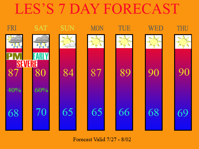
After the front, we should begin to clear out by Sat. evening/overnight, and Sunday should be dry under partly cloudy skies. The remainder of the 7 Day period looks to be dry and warm with temps. approaching 90 by the middle of next week.
Below is my 7 Day forecast:

Long Term Outlook (Aug 3rd - 11th)
The models show very little going on for the long term period. But, as in the past, the models showed nothing then all of a sudden we've been dealing with a cut off low and now a cold front. So, take the long range period with a grain of salt folks. Either way, we will see a 5-7 day period of dryness after tomorrow night's front. I think the drought will continue to maintain itself or even get worse if the long range models pan out.
Below is the latest Drought Monitor Map from this morning:

I really thought that the D3 area in SE KY would be gone, due to their recent rains. However due to the cut off on the map's data (Tues at 7am), this might be why the D3 area is not gone yet. We'll see what the map looks like next week. Also, note how the D1 area has expanded into Michigan. Also, the drought is almost extending from Coast to Coast as well. The drought is not going away at all. In fact, it is increasing in coverage.

2 comments:
You did a great job. Enjoyed your new graphics!!
Thank you =) I keep trying to not only improve the accuracy of my forecasts, but the appearance as well. I appreciate the positive feedback!
Post a Comment