I'd like to start off this blog entry by wishing everyone a Happy 4th of July!

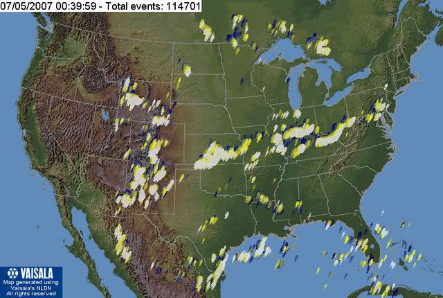
Mother Nature had her own set of fireworks today. Check out this image of Current US Lightning Strikes. This image was taken as of 8:40pm.

At the Burlington Weather Office we had a few storms roll through during the afternoon hours. CVG had a wind gust earlier of 50mph. Like CVG, we gusted to almost 50 mph, I think around 48. I picked up .38" of rain and saw a ton of lightning as well. The rain came down very heavy for a good 30 mins. The temp. was at 88.3 degrees before the storms moved in, and dropped down to 76.1 as the storms moved out. No hail to report, just vivid lightning, very heavy rain, and gusty winds. No damage or flooding to report.
Current conditions:
Partly cloudy with a temp. of 74.7 degrees and a Dew point of 71. Winds are light around 5 mph now out of the WSW.
For tonight, we can expect more scattered areas of showers and storms. No severe wx has been reported today in the Tri-state even though our tornado watch expires at 9pm. I still do not expect any severe wx overnight either.
Below, is a GR3 radar image as of 8:42pm. Notice the very heavy rain located in Central Indy in between Columbus and Greensburg. DBZ is at 62.5, which means probably an inch per hour rainfall rates. Let's hope this holds together and hits CVG and the Weather Office.

For tomorrow, we can expect another chance of showers and storms as the front begins to finally pass through the region. I think our best chances will be morning and again late in the day. I have a 50% POP for tomorrow because I think areas from Cincinnati on South stand to have the best chance.
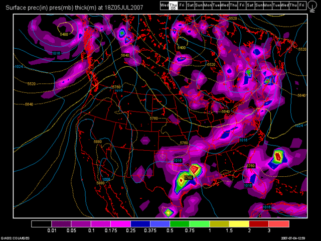
Here is the 12Z GFS's depiction of the rainfall for tomorrow afternoon. This model image is valid at 30 hours. (Thurs. 2pm)

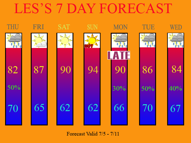
By Fri, high pressure will build in and give us a dry day with sunny skies by afternoon. The dry weather continues for the weekend with the heat really turning on by Sunday under a strong SW Flow. Sun. will be in the 90s and be the hottest day out of the next 7.
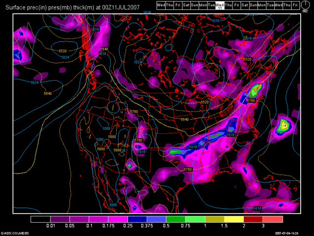
By the beginning of next week, a cold front will be dropping down from the NW. The 12Z GFS brings in a few isolated storms by late in the day on Monday. Tues. night really looks to be our best chance according to the GFS, so my highest POPS are for Tues at the present time.
Here is an image of the 12Z GFS valid at 156 hours. (Tues. 8pm)

In the 7 Day, I have a lingering chance of storms in the forecast on Wed. as the front will stall just along or South of the OH River.
Here is my updated 7 Day Forecast. The forecast is valid from 7/5 - 7/11.

Long Term Outlook (7/12 - 7/20)
At the start of the long term period, the front should finally be exiting the region by Thurs. After that, the 12Z GFS does not show very much in the way of rainfall for the remainder of the Long Term period. Highs will probably be in the upper 80s and lower 90s through the period. So, let's all hope that we can add to our rainfall totals during the next 7 days. If not, the drought may re-intensify. The rainfall we are getting now, will only stop the drought from getting worse. It will not wipe it out though. We keep getting too many hot days in between weather systems. I mentioned in my last blog entry that this pattern of wetness we are in is only a temporary one. After July 10th, we could see another hot and dry period. The models are still showing the same thing this week, that I mentioned previously.

2 comments:
redwings1How does New York look for next week?
I like your 7 day
Well you commented on the wrong one again. Clear your cache then refresh the page. I updated it last night to talk about this week.
Thanks for the positive feedback though.
Post a Comment